The GHRC published the GPM Ground Validation NASA S-Band Dual-Polarimetric (NPOL) Doppler Radar Wallops Flight Facility (WFF) dataset (http://dx.doi.org/10.5067/GPMGV/WFF/NPOL/DATA101). This dataset consists of rain rate, reflectivity, Doppler velocity, and other radar measurements obtained from the NPOL doppler radar positioned at the Wallops Flight Facility (WFF) in support of the Global Precipitation Mission (GPM). NPOL was developed by scientists at WFF and is a fully transportable and self-contained S-band (10 cm), scanning dual-polarimetric Doppler research radar that was placed near Newark, Maryland between GPM GV missions. Data files are available from December 6, 2013 thru April 28, 2017 in Universal Format (UF), with browse files in PNG format containing images of corrected radar reflectivity, differential reflectivity, specific differential phase, co-polar correlation, and Doppler velocity images. Data are tarred into daily collections of files and zipped for storage and quick download. It should be noted that this dataset does not have continuous data. Data are missing for various dates that are listed in the user guide.
GHRC News
All ongoing, near-real time datasets that are publicly available, such as the ISS LIS lightning or AMSU atmospheric temperature data, can be sent to a user as new data become available by creating a 'subscription' to that dataset. This service is only available by request. To set up a subscription with the NASA GHRC DAAC, please contact GHRC User Services we will connect with you to set up the subscription.
![]() The GHRC published the GPM Ground Validation Hydro-Estimator IPHEx dataset (http://dx.doi.org/10.5067/GPMGV/IPHEX/MULTIPLE/DATA401). This dataset contains rainfall rate estimates derived using NOAA’s Geostationary Operational Environmental Satellites (GOES) infrared (IR) brightness temperature data by researchers at the NOAA Center of Satellite Applications and Research’s (STAR) using the Hydro-Estimator (H-E) model. Rainfall rate estimates are produced every 15 minutes throughout the continental United States, but for this dataset, have been subsetted to the North Carolina region for the Integrated Precipitation and Hydrology Experiment (IPHEx) field campaign in support of Global Precipitation Measurement (GPM) ground validation. These data are available in netCDF-4 format and consists of rain rate values from May 1, 2014 through June 16, 2014.
The GHRC published the GPM Ground Validation Hydro-Estimator IPHEx dataset (http://dx.doi.org/10.5067/GPMGV/IPHEX/MULTIPLE/DATA401). This dataset contains rainfall rate estimates derived using NOAA’s Geostationary Operational Environmental Satellites (GOES) infrared (IR) brightness temperature data by researchers at the NOAA Center of Satellite Applications and Research’s (STAR) using the Hydro-Estimator (H-E) model. Rainfall rate estimates are produced every 15 minutes throughout the continental United States, but for this dataset, have been subsetted to the North Carolina region for the Integrated Precipitation and Hydrology Experiment (IPHEx) field campaign in support of Global Precipitation Measurement (GPM) ground validation. These data are available in netCDF-4 format and consists of rain rate values from May 1, 2014 through June 16, 2014.
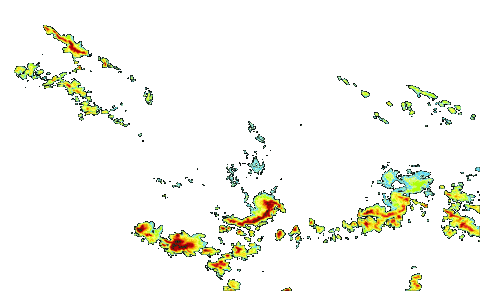
![]() The GHRC published the GPM Ground Validation Hydro-Estimator IFloodS dataset (http://dx.doi.org/10.5067/GPMGV/IFLOODS/MULTIPLE/DATA101). This dataset contains rainfall rate estimates derived using NOAA’s Geostationary Operational Environmental Satellites (GOES) infrared (IR) brightness temperature data by researchers at the NOAA Center of Satellite Applications and Research’s (STAR) using the Hydro-Estimator (H-E) model. Rainfall rate estimates are produced every 15 minutes throughout the continental United States, but for this dataset, have been subsetted to the Iowa region for the Iowa Flood Studied (IFloodS) field campaign in support of Global Precipitation Measurement (GPM) ground validation. These data are available in netCDF-3 format and consist of rain rate values from April 25, 2013 through June 30, 2013.
The GHRC published the GPM Ground Validation Hydro-Estimator IFloodS dataset (http://dx.doi.org/10.5067/GPMGV/IFLOODS/MULTIPLE/DATA101). This dataset contains rainfall rate estimates derived using NOAA’s Geostationary Operational Environmental Satellites (GOES) infrared (IR) brightness temperature data by researchers at the NOAA Center of Satellite Applications and Research’s (STAR) using the Hydro-Estimator (H-E) model. Rainfall rate estimates are produced every 15 minutes throughout the continental United States, but for this dataset, have been subsetted to the Iowa region for the Iowa Flood Studied (IFloodS) field campaign in support of Global Precipitation Measurement (GPM) ground validation. These data are available in netCDF-3 format and consist of rain rate values from April 25, 2013 through June 30, 2013.
The GHRC published the GPM Ground Validation Iowa Flood Center (IFC) NEXRAD Composite IFloodS dataset (http://dx.doi.org/10.5067/GPMGV/IFLOODS/NEXRAD/DATA101). This dataset contains rain rate estimates derived using NEXt Generation Weather RADar system (NEXRAD) radars in operation during the Iowa Flood Studies (IFloodS) field campaign, in support of Global Precipitation Measurement (GPM) ground validation. NEXRAD is a network of 160 stationary S-Band radars dispersed throughout the United States and select locations abroad. Data were gathered in the vicinity of the IFloodS field campaign which took place in Iowa and surrounding areas during April 19, 2013 through June 30, 2013. This NEXRAD Composite data product is available in netCDF-4 or ASCII format with associated reflectivity browse imagery available in GIF format.
