The NASA Global Hydrology Resource Center (GHRC) DAAC published the GPM Ground Validation Composite Satellite Overpasses OLYMPEX datast. This dataset provides brightness temperature, precipitation, and total column water vapor estimates from multiple satellite overpasses including DMSP F16-19, GCOM-W1, GPM, MetOp, NOAA, and NPP for the OLYMPEX field campaign. The OLYMPEX field campaign took place between November, 2015, and January, 2016, with additional ground sampling continuing through February, on the Olympic Peninsula in the Pacific Northwest of the United States. This field campaign provides ground-based validation support of the findings resulting from the Global Precipitation Measurement (GPM) Core Observatory satellite. Data files are available from November 1, 2015 thru May 1, 2016 in HDF-5 format.
GHRC News

We are pleased to announce two sessions at the 2018 Fall American Geophysical Union Meeting on December 10-14, 2018 in Washington, D.C:
- IN026 (Session ID#: 49371), a session on Developing Innovative Tools and Services to Enable Data Use across Broad User Communities
- NH007 (Session ID#: 52148), a session on Communicating Weather Hazard Risk to a General Audience
Please consider submitting an abstract for this Earth and Space Science Informatics session. Additional information can be found at https://fallmeeting.agu.org/2018/.
Please note that the abstract submission deadline is August 1, 2018.
IN026
IN026: Developing Innovative Tools and Services to Enable Data Use across Broad User Communities
Session ID: 49371
Session Description:
The time and effort required to discover, visualize, and analyze large quantities of information and Earth science data for research, monitoring, and decision making presents a great challenge to Earth science investigation. Existing data and information systems support experienced users, but prove difficult for new users that are unfamiliar with the variety of formats and structures in which data, metadata, and information are stored and the required methods to use them. To address these challenges, this session includes presentations that demonstrate innovative data services, tools, and approaches to assist broader user communities in discovering, visualizing, and analyzing Earth science data. The presented work may include, but is not limited to: data recipes, data and information curation efforts, data processing and analysis tools, science notebooks, structured document database development, data discovery tools, and software tips among developers.
Primary Convener: Leigh Sinclair, University of Alabama in Huntsville
Convener: Deborah Smith, University of Alabama in Huntsville
Cross-Listed: ED-Education
Information Page: https://agu.confex.com/agu/fm18/prelim.cgi/Session/49371
NH007
NH007: Communicating Weather Hazard Risk to a General Audience
Session ID: 52148
Session Description:
In this time of evolving weather and climate patterns, communicating information and potential risks of extreme weather events and their associated hazards on societies has become increasingly important. Clear communication to these populations on the associated timelines, intensities, hazards, risks and vulnerabilities associated with extreme weather hazards is critical for the effectiveness of decision making and relief efforts. Effective communication to vulnerable populations can prove challenging given the wide array of social backgrounds, experiences and perceptions of hazardous events. This age of increasing information technology, communication venues, social media, and web-based resources offers unique ways to communicate information on these hazards to a heterogeneous audience. This session solicits presentations on innovative approaches to communicate information during hazardous events which may include, but is not limited to the following: use of social media, web-tools, graphic design and education. Examples of successful and unsuccessful communication methodologies during extreme weather events are encouraged.
Primary Convener: Jordan R. Bell, NASA Marshall Space Flight Center
Conveners:
Leigh Sinclair, University of Alabama in Huntsville
Amanda (Weigel) Markert, University of Alabama in Huntsville
Cross-Listed:
A-Atmospheric Science
ED-Education
H-Hydrology
PA-Public Affairs
Information Page: https://agu.confex.com/agu/fm18/prelim.cgi/Session/52148
For the first time, the AGU Fall Meeting will be held in Washington, D.C., where we will mark the launch of AGU’s Centennial. A wide variety of events are being planned that will take advantage of this special location that will showcase our science to the U.S. and international policy community, students, and public; leverage the local scientific community, including events with the Smithsonian, National Academies, and others; and, offer field trips to view the local geology and research institutes. The Fall Meeting will also offer more workshops, as well as new Tutorial sessions, to help students and researchers learn about new approaches and techniques and introduce exciting science in other disciplines.
Please consider submitting an abstract and/or attending to help show “What Science Stands For” and to join in an exciting and informative start to AGU’s Centennial. Submissions received by the early deadline of July 25, 2018 have a chance to win a $100 U.S. gift card.
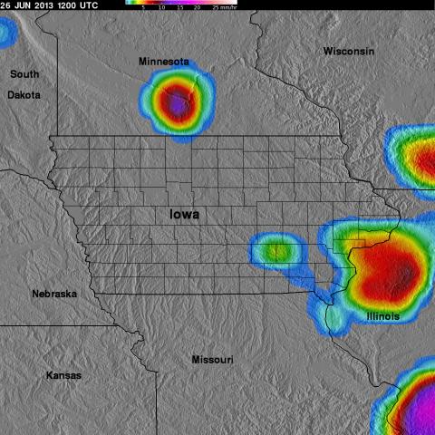 The NASA Global Hydrology Resource Center (GHRC) DAAC published the GPM Ground Validation TRMM Multi-satellite Precipitation Analysis (TMPA) IFloodS datasets. This dataset is a subset of the TMPA 3B42RT gridded precipitation real-time product selected for the time period of the GPM Ground Validation Iowa Flood Studies (IFloodS) held in Iowa during April 1, 2013 to June 30, 2013. The goals of IFloodS were to collect detailed measurements of precipitation at the Earth’s surface using ground instruments and advanced weather radars and to simultaneously collect data from satellites passing overhead. TMPA is a calibration-based sequential scheme for combining microwave (MW) and infrared (IR) precipitation estimates from multiple satellites, as well as surface precipitation gauge analyses where feasible, to produce precipitation estimates at fine scales: 3-hourly, 0.25 degree maps. The TMPA IFloodS product is available in netCDF-4 and binary formats, as well as 3-hour rainfall browse images in JPG format. It should be noted that the GPM Ground Validation TRMM Multi-satellite Precipitation Analysis (TMPA) IFloodS dataset is a temporal subset of the TMPA 3B42RT Version-7 gridded precipitation product available at https://pmm.nasa.gov/data-access/downloads/trmm. The version number of this dataset matches the original TMPA product at NASA Goddard.
 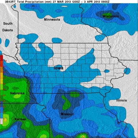 The NASA Global Hydrology Resource Center (GHRC) DAAC published the GPM Ground Validation Global Flood Monitoring System (GFMS) Flood Maps IFloodS dataset. This dataset contains global flood estimates on a 0.25 degree spatial resolution every 3 hours, from March 26, 2013 through June 30, 2013. These data are provided in support of the Iowa Flood Studies (IFloodS) experiment conducted in eastern Iowa. The goals of the IFloodS campaign were to collect detailed measurements of precipitation at the Earth’s surface using ground instruments and advanced weather radars and to simultaneously collect data from satellites passing overhead. The data are available in netCDF-4 and ASCII formats. Flood map and rain graph files are available in KMZ, JPG, and GIF formats.
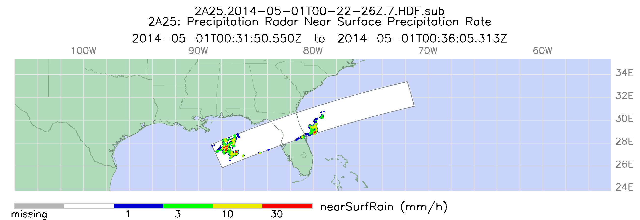
The NASA Global Hydrology Resource Center (GHRC) DAAC published the GPM Ground Validation TRMM 2A25 NRT Precipitation Radar IPHEx dataset. These data are estimates of instantaneous three-dimensional distribution of rain from the Tropical Rainfall Measuring Mission (TRMM) Precipitation Radar (PR). The TRMM 2A25 (NRT) orbital precipitation radar data from NASA GES DISC have been extracted for the southeast US region for May 1 to June 16, 2014 during the GPM Ground Validation Integrated Precipitation and Hydrology Experiment (IPHEx) field campaign. This data product contains the average rainfall rate between two predefined altitudes derived from each radar beam position. Other output data include parameters of Z-R relationships (R=aZb), integrated rain rate of each beam, range bin numbers of rain layer boundaries, and many intermediate parameters. Data files are available in HDF-4 format, while corresponding browse images are also available in PNG format. It should be noted that this dataset is constructed from the NASA GES DISC Please refer to section 2-3. 8. in the Tropical Rainfall Measuring Mission (TRMM) Precipitation Radar Algorithm Instruction Manual For Version 7 document (http://www.eorc.jaxa.jp/TRMM/documents/PR_algorithm_product_information/...) regarding caveats about the 2A25 algorithm.
