GHRC News
 The NASA Global Hydrology Resource Center (GHRC) DAAC published a new Micro Article about the Olympic Mountains Experiment (OLYMPEX) field campaign. A micro article is a short, interesting document that brings together data and key science concepts. The OLYMPEX was a Global Precipitation Measurement (GPM) ground validation field campaign that consisted of a wide variety of ground instrumentation, radars, and multiple aircrafts all which monitored the weather conditions and rainfall dropped by oceanic storm systems as they approached and traversed the Peninsula and the Olympic Mountains. The intensive observing period took place during November 2015 through February 2016. This OLYMPEX Field Campaign Micro Article can be viewed at https://ghrc.nsstc.nasa.gov/home/micro-articles/olympic-mountains-experiment-olympex.
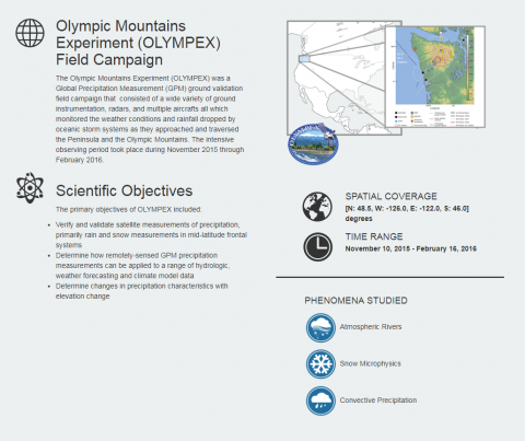
The NASA Global Hydrology Resource Center (GHRC) DAAC published the Hurricane and Severe Storm Sentinel (HS3) Cooperative Institute for Meteorological Satellite Studies (CIMSS) Cloud Top Height. This dataset contains could top height images obtained from infrared observations of the 15th Geostationary Operational Environmental Satellite (GOES-15) and the 10th Meteorological Satellite (METEOSAT-10) using the Algorithm Working Group (AWG) Cloud Height Algorithm (ACHA) for the Hurricane and Severe Storm sentinel (HS3) field campaign. Goals for the HS3 field campaign included assessing the relative roles of large-scale environment and storm-scale internal processes, addressing the controversial role of the Saharan Air Layer (SAL) in tropical storm formation and intensification, and the role of deep convection in the inner-core region of storms. The images are available for dates between August 14, 2014 and October 3, 2014 at 15 minutes intervals in PNG format.
Hurricane Florence, Tropical Storm Isaac, and Hurricane Helene are clearly visible in Worldview using LANCE NRT AMSR2 data. Please visit Worldview to follow Hurricane Florence and other storms using NRT AMSR2 data.
NASA’s Land, Atmosphere Near real-time Capability for Earth Observing Systems (LANCE) website has a new design and has been updated to include AMSR2 and LIS real-time data. LANCE leverages existing satellite data processing systems in order to provide data and imagery available from select EOS instruments (currently AIRS, AMSR2, ISS LIS, MISR, MLS, MODIS, MOPITT, OMI, OMPS, and VIIRS) within 3 hours of satellite overpass. These data meet the timely needs of applications such as numerical weather and climate prediction, forecasting and monitoring natural hazards, agriculture, air quality and disaster relief. Check out the site at https://lance.nsstc.nasa.gov/.
