We have the GHRC UWG Meeting this Tuesday, November 13th. The sidewalk by the South entrance of the NSSTC building will be under construction. Because of this, please meet a GHRC greeter at the East building entrance. The greeter will then take you to the front desk for a parking pass and guide you to the meeting room.
We will have dinner at Below the Radar, which is located at 220 Holmes Ave NE, Huntsville, AL 35801. You can find the menu for Below the Radar here.
Also, we ask that you take some time to review the following documents, websites, and content. We have included some questions that suggest what we would likey you to focus on.
GHRC UWG Homework List:
https://ghrc.nsstc.nasa.gov/home/sites/default/files/GHRC_2018UWG_HomeworkList.pdf
GHRC UWG Final Agenda:
https://ghrc.nsstc.nasa.gov/home/meetings/UWG/2018-uwg-logistics-and-agenda
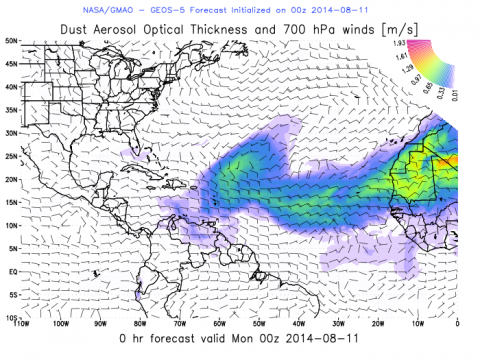 The NASA Global Hydrology Resource Center (GHRC) DAAC published the Hurricane and Severe Storm Sentinel (HS3) Global Modeling and Assimilation Office (GMAO) Dust Aerosol Optical Thickness Imagery dataset. This dataset consists of browse only imagery showing dust aerosol optical thickness and wind speed/direction from the Goddard Earth Observing System Model, version 5 (GEOS-5). These data are used to see how the Saharan Air Layer (SAL) affects hurricane development during the Hurricane and Severe Storm Sentinel (HS3) field campaign. Goals for the HS3 field campaign included assessing the relative roles of large-scale environmental and storm-scale internal processes, addressing the controversial role of the SAL in tropical storm formation and intensification, and the role of deep convection in the inner-core region of storms. The browse only data files are available for dates between August 11, 2014 and October 5, 2014 at 3-hour intervals in PNG format.
 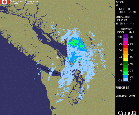 The NASA Global Hydrology Resource Center (GHRC) DAAC published the GPM Ground Validation CXSI Radar Imagery OLYMPEX dataset. This dataset contains radar reflectivity and precipitation rate images obtained from Environment and Climate Change Canada (ECCC)’s weather radar network during the GPM Ground Validation Olympic Mountain Experiment (OLYMPEX), which was conducted to validate rain and snow measurements in mid latitude frontal systems as they move from ocean to coast to mountains and to determine how remotely sensed measurements of precipitation by GPM can be applied to a range of hydrologic, weather forecasting, and climate data. These data are available as GIF images for November 19, 2015 through December 31, 2015.