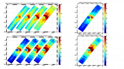
 The NASA Global Hydrology Resource Center (GHRC) DAAC published the Tropical Cyclone Intensity (TCI) Hurricane Imaging Radiometer (HIRAD) dataset. This dataset was created for the TCI field campaign from August 30, 2015 through October 23, 2015. The goal of the TCI field campaign was to improve the prediction of tropical cyclone (TC) intensity and structure change. The specific focus was to have an improved understanding of TC upper-level outflow layer processes and dynamics. These Hurricane Imaging Radiometer (HIRAD) data were obtained from the instrument onboard the NASA WB-57 aircraft flow on specific dates during the campaign. The data files include brightness temperature, rain rate, wind speed, and sea surface temperature estimates in netCDF-3 format, with corresponding browse imagery in PNG format.
GHRC News
The NASA Global Hydrology Resource Center (GHRC) DAAC published the Tropical Cyclone Intensity (TCI) Hurricane Imaging Radiometer (HIRAD) dataset. This dataset was created for the TCI field campaign from August 30, 2015 through October 23, 2015. The goal of the TCI field campaign was to improve the prediction of tropical cyclone (TC) intensity and structure change. The specific focus was to have an improved understanding of TC upper-level outflow layer processes and dynamics. These Hurricane Imaging Radiometer (HIRAD) data were obtained from the instrument onboard the NASA WB-57 aircraft flow on specific dates during the campaign. The data files include brightness temperature, rain rate, wind speed, and sea surface temperature estimates in netCDF-3 format, with corresponding browse imagery in PNG format.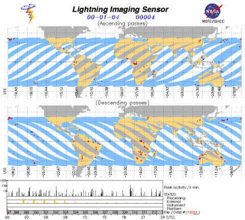 The NASA Global Hydrology Resource Center (GHRC) DAAC now has the Lightning Imaging Sensor (LIS) on TRMM Science Data and the LIS on TRMM Backgrounds datasets available in netCDF/CF format, as well as the historical HDF-4 format. TRMM LIS was used to detect the distribution and variability of total lightning occurring in the Earth’s tropical and subtropical regions. The LIS Science Data consist of lightning and lightning density measurements and are used for severe storm detection and analysis, as well as for lightning-atmosphere interaction studies. The LIS instrument makes measurements during both day and night with high detection efficiency. These data are now available in both HDF-4 and netCDF-4 formats, with corresponding browse images in GIF format. The TRMM satellite stopped collecting data on April 8, 2015 and crashed in the Indian Ocean on June 15, 2015. Note that this dataset does not currently contain uniform algorithm processing over the length of operation. There are plans to reprocess the entire dataset in the future with an updated algorithm.
Lightning Imaging Sensor (LIS) on TRMM Science Data DOI: http://dx.doi.org/10.5067/LIS/LIS/DATA201
Lightning Imaging Sensor (LIS) on TRMM Backgrounds DOI: http://dx.doi.org/10.5067/LIS/LIS/DATA101
The NASA Global Hydrology Resource Center (GHRC) DAAC published the GPM Ground Validation Naval Research Laboratory (NRL) Near-Real Time Rain Rates IFloodS dataset. This data product was created for the GPM Iowa Flood Studies (IFloodS) field campaign from April 23, 2013 through June 30, 2013. The IFloodS field campaign was a ground measurement campaign that took place in eastern Iowa. The goals of the campaign were to collect detailed measurements of precipitation at the Earth’s surface using ground instruments and advanced weather radars and to simultaneously collect data from satellites passing overhead. This NRL real time rain rates data product was produced using the Probability Matching Method with rain gauge, Defense Meteorological Satellite Program (DMSP) F15 Special Sensor Microwave - Imager (SSM/I), and DMSP F16 Special Sensor Microwave - Imager/Sounder (SSMIS) data. This data product includes rain rate estimates and files are available in netCDF-4 and binary formats, as well as corresponding browse imagery in JPG format.
DOI: http://dx.doi.org/10.5067/GPMGV/IFLOODS/INFRARED/DATA101
 The NASA Global Hydrology Resource Center (GHRC) DAAC published the GPM Ground Validation Goddard Profiling Algorithm (GPROF) 2014 IFloodS dataset. This dataset consists of precipitation data derived from microwave radiometers and sounders located on multiple satellites, including the Defense Meteorological Satellite Program (DMSP) F16-18, the Global Change Observation Mission – Water "Shizuku" (GCOM-W1), the European Space Agency's (ESA’s) Meteorological Operational satellite programme (MetOp) series, and NOAA's Polar Operational Environmental Satellites (POES) series. The data have been consistently processed for the Iowa Flood Studies (IFloodS) field campaign conducted in eastern Iowa during spring 2013. The goals of the IFloodS campaign were to collect detailed measurements of precipitation at the Earth’s surface using ground instruments and advanced weather radars and to simultaneously collect data from satellites passing overhead. The GPROF 2014 data files are available from March 31 to July 2, 2013 in HDF-5 format. It should be noted that these data are specially produced by the Precipitation Measurement Missions (PMM) for IFloodS.
The NASA Global Hydrology Resource Center (GHRC) DAAC published the GPM Ground Validation Reference Rainfall Data Product IFloodS dataset. This dataset contains hourly rainfall accumulation estimates over central and northeastern Iowa for the period of 1 May to 16 June, 2013. This product is created by combining ground-based radar estimates collected for the Iowa Flood Studies (IFloodS) campaign. The goals of the IFloodS campaign were to collect detailed measurements of precipitation at the Earth’s surface using ground instruments and advanced weather radars and to simultaneously collect data from satellites passing overhead. The data are available in gzipped ASCII files.
