GHRC News

Sample browse image

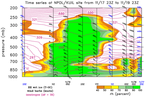
The Global Hydrology Resource Center (GHRC) DAAC published the GPM Ground Validation Upper Air Radiosonde OLYMPEX dataset (http://dx.doi.org/10.5067/GPMGV/OLYMPEX/RADIOSONDES/DATA101).

This dataset was collected from October 28, 2015 through January 16, 2016 during the GPM Ground Validation Olympic Mountain Experiment (OLYMPEX) held on the Olympic Peninsula in the Pacific Northwest of the United States. Radiosondes were released from 5 locations: 3 in US - KSLE, KUIL, and NPOL site; and 2 in Canada - ECCC instrument site and CYZT.   A total of 651 radiosondes were launched and collected during OLYMPEX from these sites. In addition, Level 4 dropsonde data were reprocessed to match the Level-4 data format and content of the radiosonde files and is also provided here. The dropsondes were released from the NASA DC-8 aircraft during specific flights in December 2015 and are published as the AVAPS dataset. This Upper Air Radiosonde dataset contains Level 0 through Level 4 data containing dew point temperature, pressure, air temperature, relative humidity, horizontal wind speed, vertical wind speed, wind direction, rise or drop rate, and geopotential height measurements.  The data files are available in ASCII, ASCII-EOL, and netCDF-3 formats, as well as Skew-T and time series plots in PNG format. The lower level datasets (Level 0 raw data through Level 2 data) are only available upon request from the NASA GHRC DAAC.

On Monday, 5/7/2018, Deborah Smith and Tammy Smith of GHRC presented the GHRC data recipes and micro articles, online content available to users that connect information and data. They described the design process used to develop new types of micro articles and the iterative process that occurs between designer and outreach team members.

IFloodS logoGHRC has published the GPM Ground Validation National Mosaic and Multi-Sensor QPE (NMQ) System IFloodS (http://dx.doi.org/10.5067/GPMGV/IFLOODS/NMQ/DATA101).

This dataset contains quality control products, real time rain rate estimates, hourly precipitation rate estimates, and three-dimensional reflectivity products. These data products are also referred to as Multi-Radar Multi-Sensor Precipitation Reanalysis for Satellite Validation (MRMS) product and were created using the NOAA NMQ System which ingests Weather Surveillance Radar 88 Doppler (WSR-88D) radar data, Rapid Update Cycle (RUC) model analysis fields, and Hydrometeorological Automated Data Systems (HADS) gauge data. The files provided in this dataset are from the NMQ system output obtained during the GPM Iowa Flood Studies (IFloodS) field campaign that occurred throughout Iowa. These data are available in ASCII, netCDF-4, and binary formats for the dates between April 1, 2013 through June 30, 2013.

Sample image taken by the team on Mt. Hopper
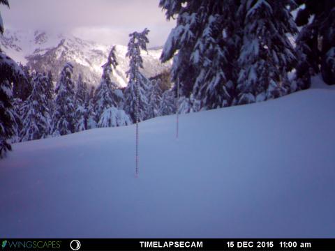
The GHRC published the GPM Ground Validation Snow Depth Monitoring System OLYMPEX dataset (http://dx.doi.org/10.5067/GPMGV/OLYMPEX/SNOWTUBE/DATA101).

This dataset consists of snow depth, temperature, and relative humidity measurements which were collected using snow depth poles, time lapse cameras, temperature/relative humidity sensors, and manual snow surveys. This dataset was collected during the GPM Ground Validation Olympic Mountain Experiment (OLYMPEX) held on the Olympic Peninsula in the Pacific Northwest of the United States. The analyzed data files are available in netCDF-3 data format. The dataset includes the individual camera photos of snow poles taken hourly during the field campaign, provided as JPG images. There are up to 3 cameras/poles per study site location. In addition, a Microsoft Excel data file contains results of a manual snow survey taken on the specific days of the Airborne Snow Observatory OLYMPEX overflights. In total, measurements contained in this dataset extend from September 5, 2014 through August 20, 2016, but the primary field campaign data were collected during the fall 2015 to spring 2016 time period.

Sample image taken by the team on Mt. Hopper


The GHRC published the GPM Ground Validation Airborne Snow Observatory (ASO) OLYMPEX dataset (http://dx.doi.org/10.5067/GPMGV/OLYMPEX/LIDAR/DATA101). This dataset consists of snow depth, bare earth surface, land surface classification and a Red, Green, Blue (RGB) composite  image, provided at 3 m spatial resolution during the GPM Ground Validation Olympic Mountains Experiment (OLYMPEX) field campaign held in the Pacific Northwest. These data were collected by a Riegl Q1560 scanning LiDAR and an ITRES CASI-1500 imaging spectrometer, both part of the NASA Airborne Snow Observatory (ASO), during two separate periods, February 8-9, 2016 and March 29-30, 2016.  A previous September 2014 flight was used to obtain no-snow measurements used for deriving snow depth. The data are provided in GeoTIFF format.

ASO Sample image

Have you used our data? Register for updates