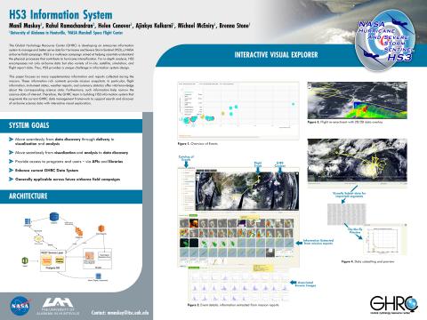
 GHRC DAAC was represented at the 2016 Winter Meeting of the Federation for Earth Science Information Partners (ESIP) by DAAC Manager Dr. Rahul Ramachandran (NASA MSFC), Operations Manager Helen Conover, GHRC system architect Manil Maskey, and GHRC-affiliated researcher Ken Keiser (all University of Alabama in Huntsville). The group had many beneficial discussions with colleagues from ESDIS, the DAACs and others in the Earth science informatics community. Maskey presented a poster on the HS3 Information System, currently under development (left). Conover and others in the ESDIS Standards Office (ESO) met with ESDIS and community experts to improve information provided to new NASA missions on International Standards Organization (ISO) compliant metadata requirements. The GHRC team is active in ESIP leadership. Conover is a member of the ESIP Finance Committee; Keiser is chair of the Constitution and Bylaws Committee and on the Executive Committee.
GHRC News

Weather Summary:
Another good day. Looks similar to yesterday in that the trof is still in position over the central part of the state with pretty homogeneous moisture overlaying the southern part. SEly winds at 10K in lo levels will augment the seabreeze on the east coast, and delay the west coast seabreeze. Look for development over Cape Sable area around 1400L. Meanwhile, there will be tstms/rw over the ocean to the NW.
Watervapor channel indicates slight drying in mid levels for tomorrow, then on Thurs PM a weak easterly wave should move thru the area. Will have to look closely at this for timing.
1032L rw
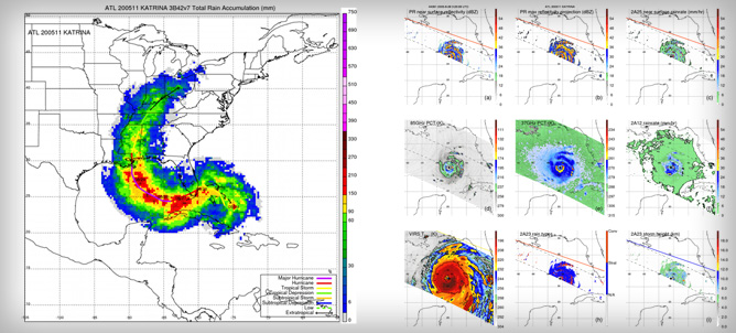
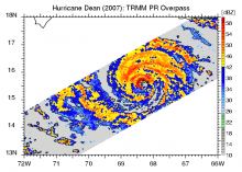 GHRC DAAC has published the TRMM Cyclone Precipitation Feature (TCPF) Database - Level 1, providing TRMM-based tropical cyclone data in a common framework for hurricane science research. This dataset aggregates observations from each of the TRMM instruments for each satellite orbit that was coincident with a tropical cyclone in any of the six TC-prone ocean basins. These swath data are co-located and subsetted to a 20-degree longitude by 20-degree latitude bounding box centered on the tropical storm, which is typically large enough to observe the various sizes of TCs and their immediate environments. The TCPF Level 1 dataset was created by researchers at Florida International University (FIU) and the University of Utah (UU) from the UU TRMM Precipitation Feature database. The TCPF database is built by extracting those precipitation features that are identified as tropical cyclones (TC) using the TC best-track data provided by National Hurricane Center or the US Navy’s Joint Typhoon Warning Center.
GHRC has acquired the Level 1 Tropical Rainfall Measuring Mission (TRMM) Tropical Cyclone Precipitation Feature (TCPF) Database, which provides TRMM-based tropical cyclone swath data. The TCPF Level 1 dataset marks the shift in GHRC's direction towards the new focus of hazardous weather.
GHRC DAAC Manager Dr. Rahul Ramachandran and UAH PI Dr. Sara Graves attended the 2015 American Geophysical Union (AGU) Fall Meeting that took place 14-18 December in San Francisco, CA. Ramachandran and GHRC team member Kaylin Bugbee served as co-conveners for three sessions, IN33B “Geocuration: Issues, Challenges and Opportunities” and PA11A, PA13B “Linking Climate Resources for Community Resilience.” Graves was a chair for the session NH43B “Natural Hazards Research and Mitigation: Global Navigation Satellite System, Data Diversity, and Emerging Technology.” GHRC staff contributed to the following posters and presentations:
· “HS3 Information System” by Manil Maskey, Helen Conover, Rahul Ramachandran, Ajinkya Kulkarni, Michael McEniry, Breanna Stone
· “Exploiting Untapped Information Resources in Earth Science” by Rahul Ramachandran, Peter Fox, Steve Kempler, Manil Maskey
· “Rethinking Approaches to Exploration and Analysis of Big Data in Earth Science” by Sara Graves, Manil Maskey
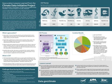
· “Geocuration Lessons Learned from the Climate Data Initiative Project” by Rahul Ramachandran, Kaylin Bugbee, Curt Tilmes and Ana Pinheiro Privette
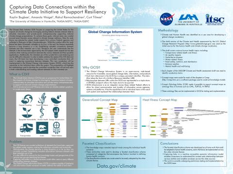
· “Capturing Data Connections within the Climate Data Initiative to Support Resiliency” by Kaylin Bugbee, Amanda Weigel, Rahul Ramachandran, Curt Tilmes
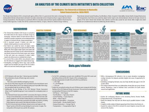
· “An Analysis of the Climate Data Initiative's Data Collection” by Kaylin Bugbee and Rahul Ramachandran
· “NASA’s Land Atmosphere Near real-time Capability for EOS (LANCE): Updates and Changing patterns in use” by Diane Davies,Karen Michael, Jeffrey Schmaltz, Sherry Harrison, Feng Ding, Phil Durbin, Ryan A. Boller, Matthew F. Cechini, Pamela Rinsland, Gang Ye and Ed Masuoka
· “Can ASCII data files be standardized for Earth Science?” by Keith D Evans, Gao Chen, Anne Wilson, Emily Law, Steve Olding, Nickolay A. Krotkov, Helen Conover
![]() On December 15, the AMSR-E SIPS at GHRC DAAC announced the availability of three near real-time AMSR2 Daily Sea Ice data sets via NASA’s Land Atmosphere Near real-time Capability for EOS (LANCE). These data sets are generated incrementally in near real-time, as data are acquired from the AMSR2 instrument on the Japanese Aerospace Exploration Agency (JAXA) GCOM-W1 satellite. LANCE AMSR2 GIBS Sea Ice imagery will be available in Worldview very soon.
On December 15, the AMSR-E SIPS at GHRC DAAC announced the availability of three near real-time AMSR2 Daily Sea Ice data sets via NASA’s Land Atmosphere Near real-time Capability for EOS (LANCE). These data sets are generated incrementally in near real-time, as data are acquired from the AMSR2 instrument on the Japanese Aerospace Exploration Agency (JAXA) GCOM-W1 satellite. LANCE AMSR2 GIBS Sea Ice imagery will be available in Worldview very soon.
You can access the data at GHRC's LANCE AMSR2 website.
