 The NASA Global Hydrology Resource Center (GHRC) DAAC published the GPM Ground Validation Environment Canada (EC) Weather Station XET C3VP dataset. This dataset consists of surface meteorological data collected at the Environment Canada (EC) XET station at the Centre for Atmospheric Research Experiments (CARE) during the Canadian CloudSat/CALIPSO Validation Project (C3VP) field campaign. The campaign took place in southern Canada in support of multiple science missions, including the NASA GPM mission, in order to improve the modeling and remote sensing of winter precipitation. The XET C3VP dataset file includes...
GHRC News & Features
02/10/2021 - 16:07
02/10/2021 - 10:15
 The NASA Global Hydrology Resource Center (GHRC) DAAC published the GPM Ground Validation Environment Canada (EC) Surface Meteorological Station C3VP dataset. This dataset consists of meteorological data collected at the Environment Canada (EC) climate station at the Centre for Atmospheric Research Experiments (CARE) during the Canadian CloudSat/CALIPSO Validation Project (C3VP) field campaign. The campaign took place in southern Canada in support of multiple science missions, including the NASA GPM mission, in order to improve the modeling and remote sensing of winter precipitation. The GPM GV EC Surface...
 02/08/2021 - 15:49
![]() The NASA Global Hydrology Resource Center (GHRC) DAAC published the UND Cloud Microphysics IMPACTS dataset. This dataset consists of cloud particle measurements collected during the Investigation of Microphysics and Precipitation for Atlantic Coast-Threatening Snowstorms (IMPACTS) field campaign. IMPACTS was a three-year sequence of winter season deployments conducted to study snowstorms over the U.S Atlantic Coast (2020-2022). The campaign aimed to (1) Provide observations critical to understanding the mechanisms of snowband formation, organization, and evolution; (2) Examine how the microphysical characteristics and likely...
The NASA Global Hydrology Resource Center (GHRC) DAAC published the UND Cloud Microphysics IMPACTS dataset. This dataset consists of cloud particle measurements collected during the Investigation of Microphysics and Precipitation for Atlantic Coast-Threatening Snowstorms (IMPACTS) field campaign. IMPACTS was a three-year sequence of winter season deployments conducted to study snowstorms over the U.S Atlantic Coast (2020-2022). The campaign aimed to (1) Provide observations critical to understanding the mechanisms of snowband formation, organization, and evolution; (2) Examine how the microphysical characteristics and likely...
02/08/2021 - 15:45
 The NASA Global Hydrology Resource Center (GHRC) DAAC published the GPM Ground Validation (GV) Environment Canada (EC) Visibility Sensor FD12P C3VP dataset. This dataset consists of visibility and precipitation data collected at the Environment Canada Canadian Climate station at the Centre for Atmospheric Research Experiments (CARE) site during the Canadian CloudSat/CALIPSO Validation Project (C3VP) field campaign. The campaign took place in southern Canada in support of multiple science missions, including the NASA GPM mission, in order to improve the modeling and remote sensing of winter precipitation. The GPM...
02/08/2021 - 15:41
 The NASA Global Hydrology Resource Center (GHRC) DAAC published the GPM Ground Validation NASA W-band Airborne Cloud Radar (WACR) C3VP dataset. This dataset consists of calibrated co- and cross-polarized radar reflectivity at 94 GHz during the Canadian CloudSat/CALIPSO Validation Project (C3VP) field campaign. The campaign took place in southern Canada in support of multiple science missions, including the NASA GPM mission, in order to improve the modeling and remote sensing of winter precipitation. The WACR is used for cloud sensing and microphysics. During C3VP, the WACR was deployed as a surface-...
02/08/2021 - 15:35
 The NASA Global Hydrology Resource Center (GHRC) DAAC published the Cloud Radar System (CRS) IMPACTS dataset. This dataset consists of calibrated radar reflectivity, Doppler velocity, linear depolarization ratio, and normalized radar cross-section estimates collected by the Cloud Radar System (CRS) onboard the NASA ER-2 high-altitude research aircraft. These data were gathered during the Investigation of Microphysics and Precipitation for Atlantic Coast-Threatening Snowstorms (IMPACTS) field campaign. IMPACTS was a three-year sequence of winter season deployments conducted to study snowstorms over the U.S Atlantic Coast (2020-2022)....
01/28/2021 - 15:35
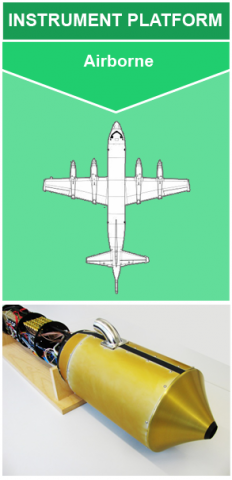
 The NASA Global Hydrology Resource Center (GHRC) DAAC published the High Altitude Imaging Wind and Rain Airborne Profiler (HIWRAP) for the IMPACTS field campaign. HIWRAP is a Doppler radar designed to measure tropospheric winds through deriving Doppler profiles from cloud and precipitation volume backscatter. The winds are generated by combining conical scan mode measurements at two different frequency bands (Ka- and Ku-band) and two different incidence angles (30 and 40 degrees). HIWRAP utilizes solid state transmitters along with a novel pulse compression scheme resulting in a system that is considerably more...
 01/11/2021 - 15:51
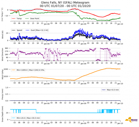
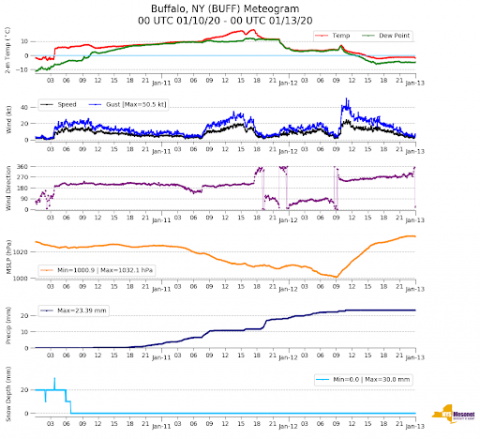 The NASA Global Hydrology Resource Center (GHRC) DAAC published the New York State Mesonet IMPACTS dataset. This dataset is a browse-only dataset and consists of temperature, wind, wind direction, mean sea level pressure, precipitation, and snow depth measurements, as well as profiler Doppler LiDAR and Microwave Radiometer (MWR) measurements from the New York State Mesonet network during the Investigation of Microphysics and Precipitation for Atlantic Coast-Threatening Snowstorms (IMPACTS) field campaign, a three-year sequence of winter season deployments conducted to study snowstorms over the U.S. Atlantic coast. IMPACTS...
 01/11/2021 - 15:42
 The NASA Global Hydrology Resource Center (GHRC) DAAC published the Weather Research and Forecasting (WRF) Model IMPACTSdataset. This dataset includes model data simulated by the Weather Research and Forecasting (WRF) model for the Investigation of Microphysics and Precipitation for Atlantic Coast-Threatening Snowstorms (IMPACTS) field campaign. IMPACTS was a three-year sequence of winter season deployments conducted to study snowstorms over the U.S Atlantic Coast (2020-2022). The campaign aimed to (1) Provide observations critical to understanding the mechanisms of snowband formation, organization, and evolution; (2) Examine how...
 12/14/2020 - 15:26
 The NASA Global Hydrology Resource Center (GHRC) DAAC published the Particle Habit Imaging and Polar Scattering Probe (PHIPS) IMPACTS dataset. This dataset consists of cloud particle imagery collected by the Particle Habit Imaging and Polar Scattering (PHIPS) probe onboard the NASA P-3 aircraft during the Investigation of Microphysics and Precipitation for Atlantic Coast-Threatening Snowstorms (IMPACTS) field campaign. IMPACTS was a three-year sequence of winter season deployments conducted to study snowstorms over the U.S Atlantic Coast (2020-2022). The campaign aimed to (1) Provide observations critical to...