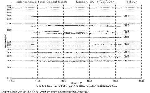
 The NASA Global Hydrology Resource Center (GHRC) DAAC published the GOES-R PLT Surface Radiance Ivanpah dataset. This dataset consists of surface reflectance and total optical depth data measured at Ivanpah Playa, Nevada during the GOES-R Post Launch Test (PLT) field campaign. The atmospheric measurements were made using an Automated Solar Radiometer (ASR), which tracks the sun throughout the day. Surface reflectance measurements were made using an ASD portable spectroradiometer and Spectralon reference panel. The GOES-R PLT field campaign took place from March to May of 2017 in support of...
GHRC News & Features
09/06/2019 - 16:09
The NASA Global Hydrology Resource Center (GHRC) DAAC published the GOES-R PLT Surface Radiance Ivanpah dataset. This dataset consists of surface reflectance and total optical depth data measured at Ivanpah Playa, Nevada during the GOES-R Post Launch Test (PLT) field campaign. The atmospheric measurements were made using an Automated Solar Radiometer (ASR), which tracks the sun throughout the day. Surface reflectance measurements were made using an ASD portable spectroradiometer and Spectralon reference panel. The GOES-R PLT field campaign took place from March to May of 2017 in support of... 09/06/2019 - 16:07
08/23/2019 - 15:14
 The NASA Global Hydrology Resource Center (GHRC) DAAC published the GPM Ground Validation Reference Precipitation IPHEx dataset. This dataset consists of 10 years (December 31, 2007-December 31, 2017) of hourly rainfall intensity at 1 km2 resolution over the core region of the Integrated Precipitation and Hydrology Experiment (IPHEx), that is centered in the Pigeon River Basin in North Carolina. The goal of the IPHEx field campaign was to evaluate the accuracy of satellite precipitation measurements and use the collected data for hydrology models in the region. Data files are available in ASCII format.
...
08/22/2019 - 15:58
08/22/2019 - 15:45
08/09/2019 - 14:57
08/08/2019 - 13:27
The NASA Global Hydrology Resource Center (GHRC) DAAC published the GOES-R PLT Geostationary Coastal and Air Pollution Event (GEO-CAPE) Airborne Simulator (GCAS) dataset. This dataset consists of solar backscattered radiation measured by the Geostationary Coastal and Air Pollution Event (GEO-CAPE) Airborne Simulator (GCAS) flown aboard a NASA ER-2 high-altitude aircraft during the GOES-R Post Launch Test (PLT) field campaign. The GOES-R PLT field campaign took place from March to May of 2017 in support of post-launch L1B product validation of the Advanced Baseline Image (ABI)...
07/25/2019 - 13:18

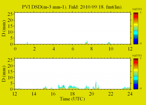 The NASA Global Hydrology Resource Center (GHRC) DAAC published the GPM Ground Validation Precipitation Video Imager (PVI) LPVEx. This dataset consists of precipitation particle images and drop size...
 07/23/2019 - 14:19
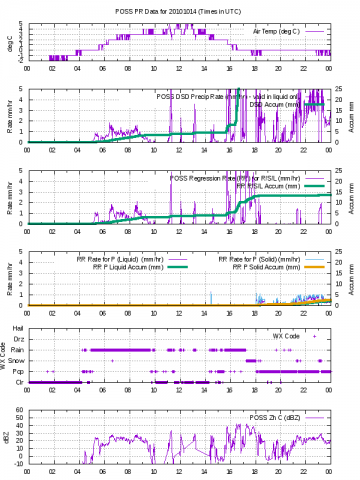 The NASA Global Hydrology Resource Center (GHRC) DAAC published the GPM Ground Validation Precipitation Occurrence Sensor System (POSS) LPVEx dataset. This dataset consists of precipitation and radar parameter estimates for both liquid and solid precipitation. Measurements were collected by the Precipitation Occurrence Sensor System (POSS) during the Global Precipitation Measurement (GPM) mission Light Precipitation Validation Experiment (LPVEx) field campaign. This field campaign took place around the Gulf of Finland in September and October of 2010. The goal of the campaign was to provide additional high-...
 07/12/2019 - 13:37
 The NASA Global Hydrology Resource Center (GHRC) DAAC published the GOES-R PLT Airborne Visible/Infrared Imaging Spectrometer (AVIRIS) dataset. This dataset consists of radiance, reflectance, water phase, and navigation data delivered by the Airborne Visible/Infrared Imaging Spectrometer (AVIRIS) flown aboard the NASA ER-2 high-altitude aircraft during the GOES-R PLT field campaign. This field campaign took place from March through May 2017 in support of post-launch L1B and L2+ product validation of the Advanced Baseline Imager (ABI) and the Geostationary Lightning Mapper (GLM) satellite...