 The NASA Global Hydrology Resource Center (GHRC) DAAC published the GPM Ground Validation Met One Rain Gauge Pairs Wallops Flight Facility (WFF) dataset. This dataset contains rain rate data from 4 rain gauge networks located in Virginia and Maryland near the Wallops Flight Facility (WFF): Nassawadox, Pocomoke, HalfDeg and Wallops Flight Facility (WFF) Assorted Gauges. These data were collected in support of the Global Precipitation Mission (GPM) Ground Validation (GV) campaign. The Met One Rain Gauge Pairs are tipping bucket precipitation gauges which collect precipitation amounts and calculate rain rates. The...
GHRC News & Features
02/01/2019 - 09:44
The NASA Global Hydrology Resource Center (GHRC) DAAC published the GPM Ground Validation Met One Rain Gauge Pairs Wallops Flight Facility (WFF) dataset. This dataset contains rain rate data from 4 rain gauge networks located in Virginia and Maryland near the Wallops Flight Facility (WFF): Nassawadox, Pocomoke, HalfDeg and Wallops Flight Facility (WFF) Assorted Gauges. These data were collected in support of the Global Precipitation Mission (GPM) Ground Validation (GV) campaign. The Met One Rain Gauge Pairs are tipping bucket precipitation gauges which collect precipitation amounts and calculate rain rates. The... 01/02/2019 - 13:21
 The NASA Global Hydrology Resource Center (GHRC) DAAC published the GPM Ground Validation Multi-Radar/Multi-Sensor (MRMS) Precipitation Reanalysis for Satellite Validation Product dataset. This dataset contains precipitation rate and type estimates, quality control products, and precipitation corrective factors products. These data products were created using the NOAA MRMS System which ingests Weather Surveillance Radar 88 Doppler (WSR-88D) radar data, Rapid Update Cycle (RAP) model analysis fields, and gauge data. It should be noted that these data products are not standard MRMS. Significant post-processing is...
 12/20/2018 - 10:25
 The NASA Global Hydrology Resource Center (GHRC) DAAC published the GPM Ground Validation Autonomous Parsivel Unit (APU) Wallops Flight Facility (WFF) dataset. This dataset consists of precipitation data including precipitation amount, precipitation rate, reflectivity in Rayleigh regime, liquid water content, drop diameter, and drop concentration obtained from six Autonomous Parsivel Units (APUs) positioned at the Wallops Flight Facility (WFF) in support of the Global Precipitation Mission (GPM). The APU is an optical laser-disdrometer based on single particle extinction that measures particle size and fall...
 11/15/2018 - 13:36
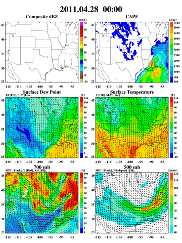 The NASA Global Hydrology Resource Center (GHRC) DAAC published the GPM Ground Validation Weather Research and Forecasting (WRF) Images MC3E dataset. This data consists of browse only images showing radar reflectivity, radar echo top, convective available potential energy (CAPE), temperature, geopotential height, wind speed, relative humidity, rain water, snow, cloud water, cloud ice, and graupel. These data were simulated by the Weather Research and Forecasting (WRF) for the period of the GPM Ground Validation Mid-latitude Continental Convective Cloud Experiment (MC3E) field campaign. The...
 11/07/2018 - 13:32
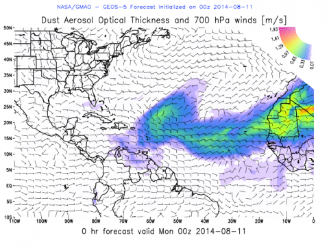 The NASA Global Hydrology Resource Center (GHRC) DAAC published the Hurricane and Severe Storm Sentinel (HS3) Global Modeling and Assimilation Office (GMAO) Dust Aerosol Optical Thickness Imagery dataset. This dataset consists of browse only imagery showing dust aerosol optical thickness and wind speed/direction from the Goddard Earth Observing System Model, version 5 (GEOS-5). These data are used to see how the Saharan Air Layer (SAL) affects hurricane development during the Hurricane and Severe Storm Sentinel (HS3) field campaign. Goals for the HS3 field campaign included assessing the relative roles...
 10/31/2018 - 08:52
The NASA Global Hydrology Resource Center (GHRC) DAAC published the AMSU/MSU Day/Month Temperature Anomalies and Annual Cycle V6 datasets. These datasets consist of temperature anomalies and annual cycle temperatures derived from the Microwave Sounding Unit (MSU) and the Advanced Microwave Sounding Unit-A (AMSU-A) radiance data since January 1978. All products are derived for four bulk layers of the atmosphere: the lower stratosphere, tropopause, mid-troposphere, and lower troposphere. The datasets begin on January 1, 1978, and are still currently ongoing. The data are available in netCDF-4 and ASCII formats. In addition, the AMSU/MSU Day/Month Temperature Anomalies and Annual Cycle V5 datasets have been retired. Please now refer to the V6 datasets for the most up-to-date and...
10/09/2018 - 11:15
09/27/2018 - 11:06
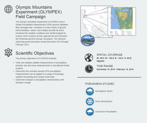 The NASA Global Hydrology Resource Center (GHRC) DAAC published a new Micro Article about the Olympic Mountains Experiment (OLYMPEX) field campaign. A micro article is a short, interesting document that brings together data and key science concepts. The OLYMPEX was a Global Precipitation Measurement (GPM) ground validation field campaign that consisted of a wide variety of ground instrumentation, radars, and multiple aircrafts all which monitored the weather conditions and rainfall dropped by oceanic storm systems as they approached and traversed the Peninsula and the Olympic Mountains. The intensive observing period took...
09/24/2018 - 10:12
The NASA Global Hydrology Resource Center (GHRC) DAAC published the Hurricane and Severe Storm Sentinel (HS3) Cooperative Institute for Meteorological Satellite Studies (CIMSS) Cloud Top Height. This dataset contains could top height images obtained from infrared observations of the 15th Geostationary Operational Environmental Satellite (GOES-15) and the 10th Meteorological Satellite (METEOSAT-10) using the Algorithm Working Group (AWG) Cloud Height Algorithm (ACHA) for the Hurricane and Severe Storm sentinel (HS3) field campaign. Goals for the HS3 field campaign included assessing the relative roles of large-scale environment and storm-scale internal processes, addressing the controversial role of the Saharan Air Layer (SAL) in tropical storm formation and intensification, and...
09/10/2018 - 15:35
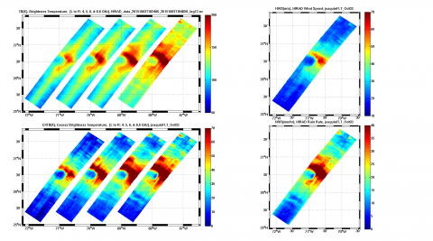 The NASA Global Hydrology Resource Center (GHRC) DAAC published the Tropical Cyclone Intensity (TCI) Hurricane Imaging Radiometer (HIRAD) dataset. This dataset was created for the TCI field campaign from August 30, 2015 through October 23, 2015. The goal of the TCI field campaign was to improve the prediction of tropical cyclone (TC) intensity and structure change. The specific focus was to have an improved understanding of TC upper-level outflow layer processes and dynamics. These Hurricane Imaging Radiometer (HIRAD) data were obtained from the instrument onboard the NASA WB-57 aircraft flow...