GHRC News & Features

05/01/2018 - 16:18

Sample image taken by the team on Mt. HopperThe GHRC published the GPM Ground Validation Snow Depth Monitoring System OLYMPEX dataset (http://dx.doi.org/10.5067/GPMGV/OLYMPEX/SNOWTUBE/DATA101).

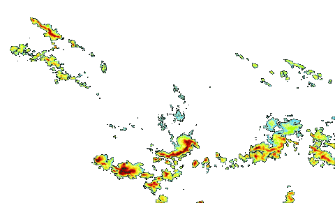
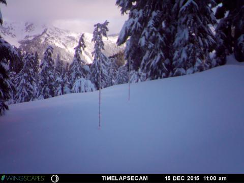
This dataset consists of snow depth, temperature, and relative humidity measurements which were collected using snow depth poles, time lapse cameras, temperature/relative humidity sensors, and manual snow surveys. This dataset was collected during the GPM Ground Validation Olympic Mountain Experiment (OLYMPEX) held on the Olympic Peninsula in the Pacific Northwest of the United States. The...

04/30/2018 - 16:17


The GHRC published the GPM Ground Validation Airborne Snow Observatory (ASO) OLYMPEX dataset (http://dx.doi.org/10.5067/GPMGV/OLYMPEX/LIDAR/DATA101). This dataset consists of snow depth, bare earth surface, land surface classification and a Red, Green, Blue (RGB) composite  image, provided at 3 m spatial resolution during the GPM Ground Validation Olympic Mountains Experiment (OLYMPEX) field campaign held in the Pacific Northwest. These data were collected by a Riegl Q1560 scanning LiDAR and an ITRES CASI-1500 imaging spectrometer, both part of the NASA Airborne Snow Observatory (ASO), during two separate periods, February 8-9, 2016 and March 29-30, 2016.  A previous September 2014 flight was used to obtain no-snow measurements used for deriving snow depth. The...

04/27/2018 - 10:06


The GHRC published the GPM Ground Validation NASA S-Band Dual-Polarimetric (NPOL) Doppler Radar Wallops Flight Facility (WFF) dataset (http://dx.doi.org/10.5067/GPMGV/WFF/NPOL/DATA101). This dataset consists of rain rate, reflectivity, Doppler velocity, and other radar measurements obtained from the NPOL doppler radar positioned at the Wallops Flight Facility (WFF) in support of the Global Precipitation Mission (GPM). NPOL was developed by  scientists at WFF and is a fully transportable and self-contained S-band (10 cm), scanning dual-polarimetric Doppler research radar that was placed near Newark, Maryland between GPM GV missions. Data files are available from December 6, 2013 thru April 28, 2017 in Universal Format (UF), with browse files in PNG format containing...

03/28/2018 - 22:29

IPHEx logoThe GHRC published the GPM Ground Validation Hydro-Estimator IPHEx dataset (http://dx.doi.org/10.5067/GPMGV/IPHEX/MULTIPLE/DATA401). This dataset contains rainfall rate estimates derived using NOAA’s Geostationary Operational Environmental Satellites (GOES) infrared (IR) brightness temperature data by researchers at the NOAA Center of Satellite Applications and Research’s (STAR) using the Hydro-Estimator (H-E) model. Rainfall rate estimates are produced every 15 minutes throughout the continental United...

03/28/2018 - 12:20

IFloodS logoThe GHRC published the GPM Ground Validation Hydro-Estimator IFloodS dataset (http://dx.doi.org/10.5067/GPMGV/IFLOODS/MULTIPLE/DATA101). This dataset contains rainfall rate estimates derived using NOAA’s Geostationary Operational Environmental Satellites (GOES) infrared (IR) brightness temperature data by researchers at the NOAA Center of Satellite Applications and Research’s (STAR) using the Hydro-Estimator (H-E) model. Rainfall rate estimates are produced every 15 minutes throughout the continental United States,...

03/22/2018 - 16:14

Sample browse image

The GHRC published the GPM Ground Validation Iowa Flood Center (IFC) NEXRAD Composite IFloodS dataset (http://dx.doi.org/10.5067/GPMGV/IFLOODS/NEXRAD/DATA101). This dataset contains rain rate estimates derived using NEXt Generation Weather RADar system (NEXRAD) radars in operation during the Iowa Flood Studies (IFloodS) field campaign, in support of Global Precipitation Measurement (GPM) ground validation. NEXRAD is a network of 160 stationary S-Band...

03/22/2018 - 08:58

OLYMPEX logoThe GHRC published the GPM Ground Validation CAX1 Radar CFradial format OLYMPEX dataset (http://dx.doi.org/10.5067/GPMGV/OLYMPEX/XBAND/DATA301). This dataset consists of radar parameters, such as Radar reflectivity, Doppler velocity, Doppler width, Differential reflectivity, and Signal quality index, provided on a 0.4 to 1.0 km spatial resolution within the OLYMPEX field campaign study region in the state of Washington. These data were obtained for the GPM Ground Validation OLYMPEX field campaign by the dual polarization X-band “CAX1” portable scanning...

03/14/2018 - 10:23

IPHEx logo

The GHRC published the GPM Ground Validation National Mosaic and Multi-Sensor QPE (NMQ) System IPHEx dataset (http://dx.doi.org/10.5067/GPMGV/IPHEX/NMQ/DATA101). This dataset consists of six different data products: precipitation rate, hourly rainfall accumulation, daily rainfall accumulation, hybrid scan reflectivity, three-dimensional reflectivity, and vertically integrated liquid content estimates. These data products were created using the NOAA NMQ System which ingests Weather Surveillance Radar 88 Doppler (...

03/06/2018 - 11:18


The Global Hydrology Resource Center (GHRC) DAAC has published all four of the GPM Ground Validation NEXRAD Level III IFloodS datasets. The purpose of the IFloodS campaign was to help support the ground validation of the Global Precipitation Measurement (GPM). NEXt Generation Weather RADar system (NEXRAD) Level-II data were previously published.  These Level-III NEXRAD precipitation products were gathered from Unidata for four NEXRAD stations in the vicinity of the IFloodS campaign during March 29, 2013 through June 18, 2013. These datasets contain data files of digital instantaneous precipitation rate (DPR) and storm total accumulation estimates (DTA) in NIDS binary format. For a complete archive of data from each station beyond the IFloodS time period, please...

02/26/2018 - 09:42


GHRC DAAC has published the NOXP IPHEx dataset: http://dx.doi.org/10.5067/GPMGV/IPHEX/NOXP/DATA101

The GPM Ground Validation NOAA X-band dual-Polarimetric radar (NOXP) IPHEx dataset consists of differential reflectivity, differential phase shift, co-polar cross correlation, radial Doppler velocity, spectrum width, signal index, melting layer index, reflectivity, drop size distribution, and rainfall rate observations, as well as other radar parameters, collected by NOXP mobile radar during the GPM Integrated Precipitation and Hydrology Experiment (IPHEx) field campaign. The IPHEx field campaign occurred in the Southern Appalachians, spanning into the Piedmont and Coastal Plain regions of North Carolina. The NOXP radar, operated by the NOAA National Severe...

Have you used our data? Register for updates