 The NASA Global Hydrology Resource Center (GHRC) DAAC published the GOES-R PLT Field Campaign Airborne Visible/Infrared Imaging Spectrometer Next Generation (AVIRIS-NG) dataset. This dataset consists of radiance, reflectance, water phase, and navigation data collected by the Airborne Visible/Infrared Imaging Spectrometer Next Generation (AVIRIS-NG) for the GOES-R Post Launch Test (PLT) field campaign. The GOES-R PLT field campaign took place from March to May of 2017 in support of post-launch L1B and L2+ product validation of the Advanced Baseline Imager (ABI) and the Geostationary Lightning...
GHRC News & Features
 The NASA Global Hydrology Resource Center (GHRC) DAAC published the GOES-R PLT Field Campaign Airborne Visible/Infrared Imaging Spectrometer Next Generation (AVIRIS-NG) dataset. This dataset consists of radiance, reflectance, water phase, and navigation data collected by the Airborne Visible/Infrared Imaging Spectrometer Next Generation (AVIRIS-NG) for the GOES-R Post Launch Test (PLT) field campaign. The GOES-R PLT field campaign took place from March to May of 2017 in support of post-launch L1B and L2+ product validation of the Advanced Baseline Imager (ABI) and the Geostationary Lightning...
 The NASA GHRC DAAC is currently prepping for the IMPACTS data publication to ensure a quick turn-around on publishing after receiving the full dataset. These prep efforts include sending out a Questionnaire Form to the PI for each dataset, which is an extensive form describing the data to help with documentation. Also, we have requested a sample file for each data format. We will use the information provided to create a user guide and metadata generation code for each dataset. So far, we have received sample data for 48 datasets and Questionnaire Forms for 52 datasets. Also, we have completed draft user guides for 38 datasets...
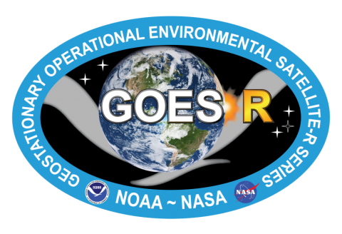
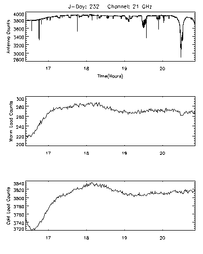 The NASA Global Hydrology Resource Center (GHRC) DAAC published the CAMEX-3 DC-8 Airborne Multichannel Microwave Radiometer (AMMR). This dataset is a browse-only dataset that consists of plotted digital count measurements collected by the Airborne Multichannel Microwave Radiometer (AMMR) during the third field campaign in the Convection And Moisture EXperiment (CAMEX) series, CAMEX-3. This field campaign took place from August to September 1998 based out of Patrick Air Force Base in Florida, with the purpose of studying the various aspects of tropical cyclones in the region. The AMMR was mounted onboard the NASA DC-8 aircraft. Daily browse files in GIF format are...
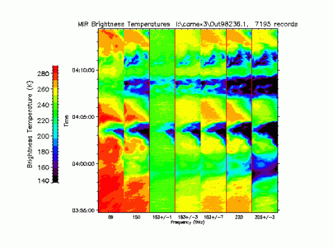 The NASA Global Hydrology Resource Center (GHRC) DAAC published the CAMEX-3 ER-2 Millimeter-wave Imaging Radiometer (MIR) dataset. This dataset is a browse-only dataset containing plots of brightness temperature measurements collected by the Millimeter-wave Imaging Radiometer (MIR) in support of the third field campaign in the Convection And Moisture EXperiment (CAMEX) series, CAMEX-3. This field campaign took place from August to September 1998 based out of Patrick Air Force Base in Florida, with the purpose of studying various aspects of tropical cyclones in the region. During CAMEX-3, MIR operated onboard the NASA ER...
 The NASA Global Hydrology Resource Center (GHRC) DAAC published the TCSP European Centre for Medium-Range Weather Forecasts (ECMWF) dataset. This dataset consists of three-hour forecast/analysis data for the Tropical Cloud Systems and Processes (TCSP) field campaign, supplied by ECMWF. The TCSP field campaign was conducted from July 1 through July 27, 2005 out of the Juan Santamaria Airfield in San Jose, Costa Rica. TCSP collected data for research and documentation of cyclogenesis, the interaction of temperature, humidity, precipitation, wind, and air pressure that creates ideal birthing conditions for tropical storms,...
 The NASA Global Hydrology Resource Center (GHRC) DAAC published the ACES Aircraft and Mechanical Data. This dataset consists of aircraft (e.g. pitch, roll, yaw) and mechanical (e.g. aircraft engine speed, tail commands, fuel levels) data recorded by the Altus II Unmanned Aerial Vehicle (Altus II UAV) system during the Altus Cumulus Electrification Study (ACES) based at the Naval Air Facility Key West in Florida. ACES aimed to provide extensive observations of the cloud electrification process and its effects by using the Altus II UAV to collect cloud top observations of thunderstorms. The campaign also worked to validate...
 The NASA Global Hydrology Resource Center (GHRC) DAAC published the NAMMA Raw DC-8 Dropsonde dataset. This dataset consists of high-resolution vertical profiles of ambient pressure, temperature, relative humidity, wind speed, and wind direction obtained by the DC-8 dropsonde system during the NASA African Monsoon Multidisciplinary Analyses (NAMMA) field campaign. The NAMMA field campaign was based in the Cape Verde Island, 350 miles off the coast of Senegal in west Africa. Commencing in August 2006, NASA scientists employed surface observation networks and aircraft to characterize the evolution and structure of African...
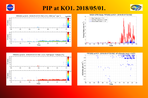 The NASA Global Hydrology Resource Center (GHRC) DAAC published the GPM Ground Validation Precipitation Imaging Package (PIP) ICE-POP dataset. This dataset includes precipitation measurements and video images collected by the Precipitation Imaging Package (PIP) during the International Collaborative Experiments for Pyeongchang 2018 Olympic and Paralympic Winter Games (ICE-POP) field campaign in South Korea. The two major objectives of ICE-POP were to study severe winter weather events in regions of complex terrain and improve the short-term forecasting of such events. These data contributed to the Global...


