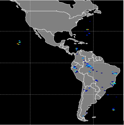
 The NASA Global Hydrology Resource Center (GHRC) DAAC has published the data recipe titled ISS LIS Lightning Flash Location Quickview using Python 3.0 and GIS. This data recipe enables the visualization of lightning flash locations across user-selected ISS LIS swath data files. The Python code can plot the data directly, or create a CSV file for use with other software, such as ESRI ArcMap. The process can now be executed using Python 3.0. The new data recipe is available at: https://ghrc.nsstc.nasa.gov/home/data-recipes/iss-lis-lightning-flash-location-quickview-using-python-30-and-gis
GHRC News
The NASA Global Hydrology Resource Center (GHRC) DAAC has published the data recipe titled ISS LIS Lightning Flash Location Quickview using Python 3.0 and GIS. This data recipe enables the visualization of lightning flash locations across user-selected ISS LIS swath data files. The Python code can plot the data directly, or create a CSV file for use with other software, such as ESRI ArcMap. The process can now be executed using Python 3.0. The new data recipe is available at: https://ghrc.nsstc.nasa.gov/home/data-recipes/iss-lis-lightning-flash-location-quickview-using-python-30-and-gis
The NASA Global Hydrology Resource Center (GHRC) DAAC published the GOES-R PLT Geostationary Coastal and Air Pollution Event (GEO-CAPE) Airborne Simulator (GCAS) dataset. This dataset consists of solar backscattered radiation measured by the Geostationary Coastal and Air Pollution Event (GEO-CAPE) Airborne Simulator (GCAS) flown aboard a NASA ER-2 high-altitude aircraft during the GOES-R Post Launch Test (PLT) field campaign. The GOES-R PLT field campaign took place from March to May of 2017 in support of post-launch L1B product validation of the Advanced Baseline Image (ABI) and the Geostationary Lightning Mapper (GLM). Data files in HDF-5 format are available for March 21, 2017 through May 14, 2017.

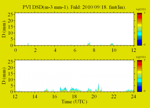 The NASA Global Hydrology Resource Center (GHRC) DAAC published the GPM Ground Validation Precipitation Video Imager (PVI) LPVEx. This dataset consists of precipitation particle images and drop size distribution (DSD) data collected by the Precipitation Video Imager (PVI) during the Global Precipitation Measurement (GPM) mission Light Precipitation Validation Experiment (LPVEx) field campaign. This field campaign took place around the Gulf of Finland in September and October of 2010. The goal of the campaign was to provide additional high-latitude, light rainfall measurements for the improvement of GPM satellite precipitation algorithms. The PVI instrument was designed by Dr. Larry Bliven at NASA Wallops Flight Facility. Data files are available from September 17, 2010 through May 11, 2011 in Excel format and contain the average, minimum, and logarithmic DSD bin sizes and number of particles per unit time. Browse images are available in BMP and JPG formats. It should be noted that while the LPVEx campaign officially took place in September and October 2010 in the Gulf of Finland, PVI instruments were operational after the campaign with data extending to May 11, 2011.
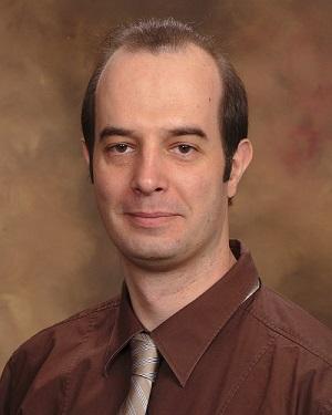 Dr. Pierre Kirstetter, GHRC DAAC User Working Group chair, is spotlighted on the NASA EarthData website, "Who Uses NASA Earth Science Data?" Pierre uses NASA Earth Science data for improving our understanding of precipitation and flooding. Dr. Pierre Kirstetter, Associate Professor, the School of Meteorology and the School of Civil Engineering and Environmental Science, University of Oklahoma; Faculty Member, Advanced Radar Research Center, University of Oklahoma; Affiliate, National Severe Storms Laboratory, Norman, OK.
Read more: User Profile: Dr. Pierre Kirstetter
