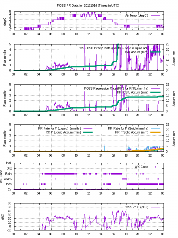
 The NASA Global Hydrology Resource Center (GHRC) DAAC published the GPM Ground Validation Precipitation Occurrence Sensor System (POSS) LPVEx dataset. This dataset consists of precipitation and radar parameter estimates for both liquid and solid precipitation. Measurements were collected by the Precipitation Occurrence Sensor System (POSS) during the Global Precipitation Measurement (GPM) mission Light Precipitation Validation Experiment (LPVEx) field campaign. This field campaign took place around the Gulf of Finland in September and October of 2010. The goal of the campaign was to provide additional high-latitude, light rainfall measurements for the improvement of GPM satellite precipitation algorithms. The POSS dataset files are available from September 18, 2010 through April 20, 2011 for two POSS sites: Emasalo and Jarvenpaa. The data files are in CSV format with browse imagery in PNG format. It should be noted that the LPVEx field campaign officially took place in September and October 2010, but individual data sets, such as the POSS dataset discussed here, provided data beyond the campaign.
GHRC News
The NASA Global Hydrology Resource Center (GHRC) DAAC published the GPM Ground Validation Precipitation Occurrence Sensor System (POSS) LPVEx dataset. This dataset consists of precipitation and radar parameter estimates for both liquid and solid precipitation. Measurements were collected by the Precipitation Occurrence Sensor System (POSS) during the Global Precipitation Measurement (GPM) mission Light Precipitation Validation Experiment (LPVEx) field campaign. This field campaign took place around the Gulf of Finland in September and October of 2010. The goal of the campaign was to provide additional high-latitude, light rainfall measurements for the improvement of GPM satellite precipitation algorithms. The POSS dataset files are available from September 18, 2010 through April 20, 2011 for two POSS sites: Emasalo and Jarvenpaa. The data files are in CSV format with browse imagery in PNG format. It should be noted that the LPVEx field campaign officially took place in September and October 2010, but individual data sets, such as the POSS dataset discussed here, provided data beyond the campaign.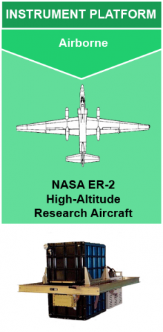 The NASA Global Hydrology Resource Center (GHRC) DAAC published the Cloud Physics LiDAR (CPL) Instrument Micro Article. The CPL instrument provides high-resolution measurements for aerosol and cirrus cloud studies. This Micro Article provides an overview of the CPL instrument and its applications to support GHRC’s current and future CPL datasets. The new Cloud Physics LiDAR Micro Article is available at: https://ghrc.nsstc.nasa.gov/home/micro-articles/instrument-cloud-physics-lidar-cpl
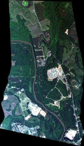 The NASA Global Hydrology Resource Center (GHRC) DAAC published the GOES-R PLT Airborne Visible/Infrared Imaging Spectrometer (AVIRIS) dataset. This dataset consists of radiance, reflectance, water phase, and navigation data delivered by the Airborne Visible/Infrared Imaging Spectrometer (AVIRIS) flown aboard the NASA ER-2 high-altitude aircraft during the GOES-R PLT field campaign. This field campaign took place from March through May 2017 in support of post-launch L1B and L2+ product validation of the Advanced Baseline Imager (ABI) and the Geostationary Lightning Mapper (GLM) satellite instruments. The GOES-R PLT AVIRIS data files are available from April 11, 2017 through May 14, 2017 in ASCII and binary formats along with browse imagery files in JPG format. It should be noted that the ER-2 aircraft did not operate each day of the campaign; therefore, AVIRIS data are only available on aircraft flight days. Also, flights during the beginning of the campaign were either test flights or flights taking placing at night. Because of this, no AVIRIS data are available for the initial parts of the campaign.
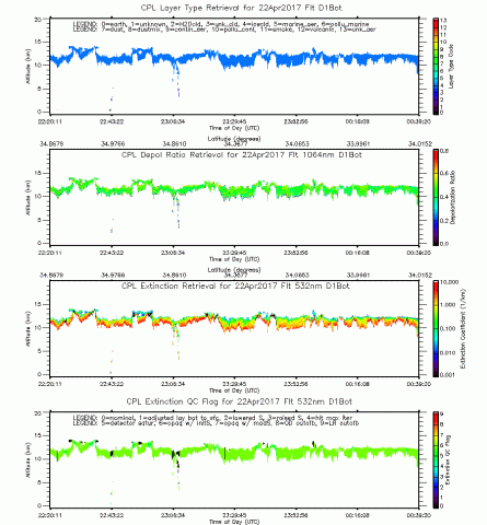 The NASA Global Hydrology Resource Center (GHRC) DAAC published the GOES-R PLT Cloud Physics LiDAR (CPL) dataset. This dataset consists of backscatter coefficient, lidar depolarization ratio, layer top/base height, layer type, particulate extinction coefficient, ice water content, and layer/cumulative optical depth data collected from the Cloud Physics LiDAR instrument flown aboard the NASA ER-2 high-altitude aircraft during the GOES-R Post Launch Test (PLT) field campaign. The GOES-R PLT field campaign supported post-launch L1B and L2+ product validation of the Advanced Baseline Imager (ABI) and the Geostationary Lightning Mapper (GLM). The CPL instrument is a multi-wavelength backscatter LiDAR that provides multi-wavelength measurements of cirrus clouds and aerosols with high temporal and spatial resolution. Data files are available from April 13, 2017 through May 14, 2017 in HDF-5 format with layer information in ASCII text files. Browse imagery files in GIF format are also available. It should be noted that the ER-2 aircraft did not operate each day of the campaign, therefore, data are only available on flight days. There were some dates during the campaign when CPL signals were weak or noisy, prompting adjustments in data processing.
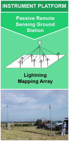 The NASA Global Hydrology Resource Center (GHRC) DAAC published the fifth Instrument Micro Article. This Micro Article is for the ground-based lightning mapping arrays (LMAs). GHRC has initially published data for seven LMAs for the GOES-R Post Launch Test field campaign. In addition, this will support future LMAs that will be published in the future. The LMAs provide high resolution, three-dimensional observations of lightning.
The new LIghtning Mapping Array Micro Article is available at:
