GHRC News
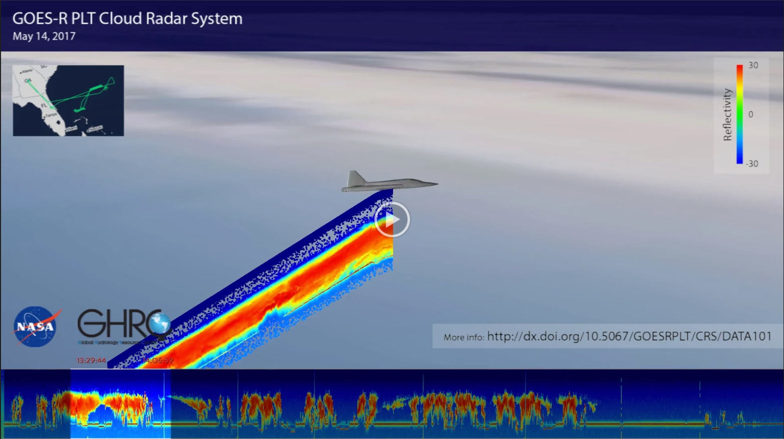
The NASA Global Hydrology Resource Center (GHRC) DAAC was selected to host many of the datasets associated with the GOES-R Post Launch Test field campaign. The campaign took place from March to May 2017. This was a joint NASA / NOAA effort with several NASA resources being used to support the calibration and validation of the Advanced Baseline Imager (ABI) and Geostationary Lightning Mapper (GLM). This included the NASA ER-2 aircraft that carried a number of instruments, such as the Cloud Radar System (CRS) shown here. The CRS is a nadir pointing radar that provides high-resolution profiles of reflectivity and Doppler velocity observations. It is capable of detecting cirrus clouds, precipitation, and other features from the aircraft’s location to the surface. This video is a demonstration of GHRC working to visualize the CRS data as part of the larger Field Campaign Explorer project. The video follows the ER-2 from 1256 UTC to 1903 UTC on May 14, 2017 as the aircraft flew over storms in the Atlantic Ocean east of Florida. As the ER-2 moves, the CRS nadir pointing observations are added. Furthermore, at the bottom of the video are the CRS data “unrolled” from start to stop (and moving in time from left to right) in a cross sectional view that is perpendicular to the flight track. As the video progresses, a highlight bar covering 37 minutes of time shows the observations in relation to the ER-2 animation. The upper left shows the full ER-2 flight track for this day.
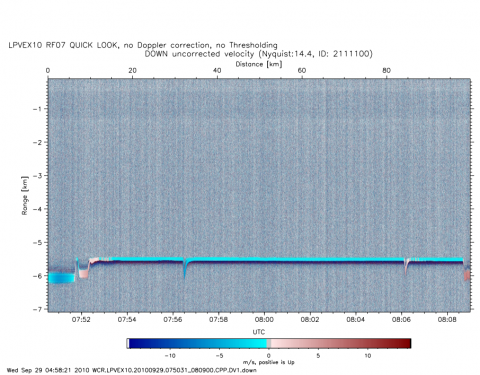 The NASA Global Hydrology Resource Center (GHRC) Distributed Active Archive Center (DAAC) published the GPM Ground Validation Wyoming Cloud Radar (WCR) LPVEx V2 dataset. This dataset includes reflectivity and Doppler velocity measurements obtained by the Wyoming Cloud Radar (WCR) flown on board the University of Wyoming King Air (UWKA) aircraft, as well as aircraft navigation parameters. These data were collected as part of the Light Precipitation Validation Experiment (LPVEx) in September and October of 2010 around the Gulf of Finland. The dataset was collected to aid in achieving the overarching goals of LPVEx, to conduct a comprehensive evaluation of precipitation algorithms for current and future satellite platforms and to detect and understand the process of light rainfall formation at high latitudes. Data files are available in netCDF-3 format from September 16 through October 20, 2010 along with browse imagery in PDF and PNG format. It should be noted that the UWKA aircraft did not operate each day of the campaign, therefore, data are only available on flight days.
The NASA Global Hydrology Resource Center (GHRC) DAAC updated the GPM Ground Validation McGill Vertical Pointing X-Band (VertiX) Radar GCPEx dataset by adding GIF imagery. This dataset consists of radar reflectivity and Doppler velocity data collected by the Vertically Pointing X-band (VertiX) radar during the Global Precipitation Measurement (GPM) mission Cold-season Precipitation Experiment (GCPEx) field campaign in Ontario, Canada during the 2011-2012 winter season. VertiX can detect all precipitation targets and some ice clouds, as well as measure the Doppler velocity of precipitation targets. These measurements contributed to the overarching goal of GCPEx to collect various snowfall data for the improvement of GPM satellite winter precipitation estimates. These data files are available from January 15 through February 29, 2012 in netCDF-3 format with browse imagery available in GIF format. It should be noted that for dates that have 2 netCDF-3 files, there is a gap in the data recording time between the end of the "*.nc" file and the beginning of the "*_1.nc" file.
