GHRC News

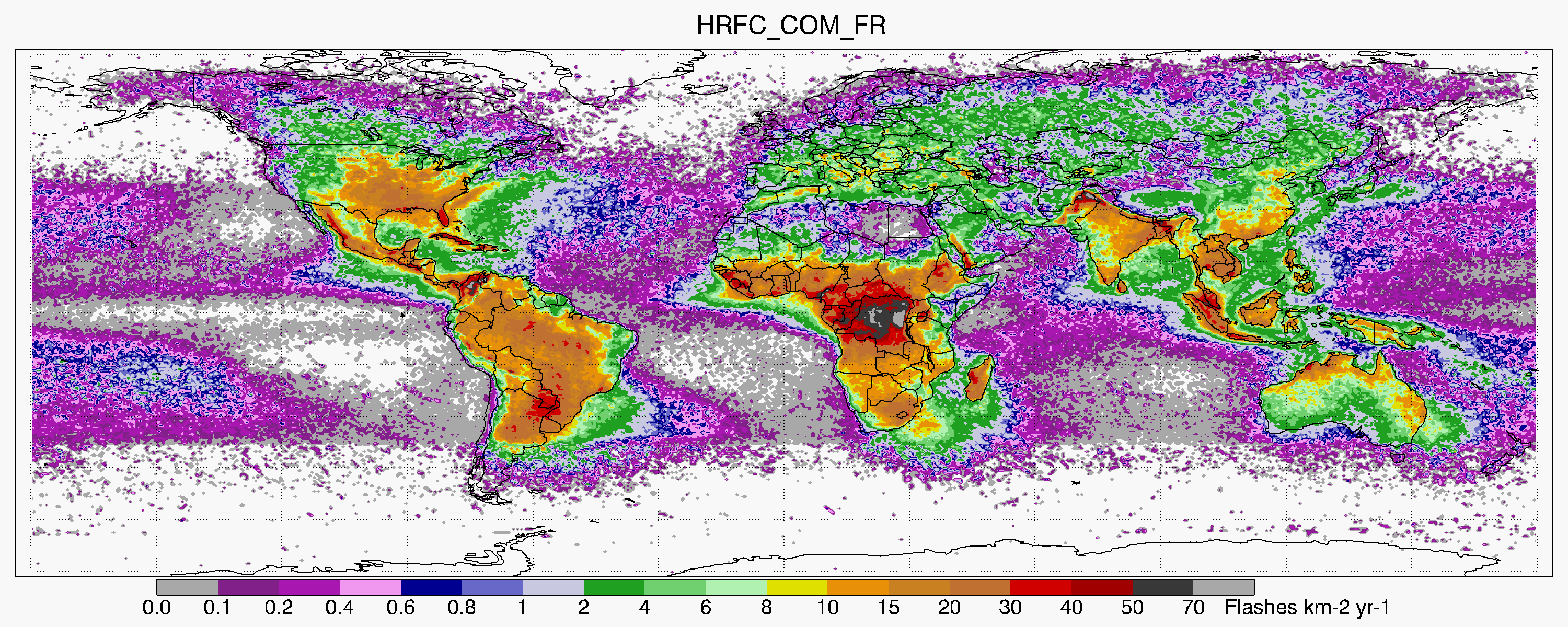
The GHRC DAAC has published an update to the LIS/OTD Gridded Lightning Climatology Data Collection (collection DOI: http://dx.doi.org/10.5067/LIS/LIS-OTD/DATA311), to incorporate Lightning Imaging Sensor (LIS) data from the last year of data from the TRMM mission. This collection comprises the ten LIS/OTD Gridded Lightning Climatology Datasets listed below. These ten data sets offer full, annual, monthly and diurnal climatologies of lightning observed from space from May 1995 through December 2014, including both Optical Transient Detector and TRMM Lightning Imaging Sensor, at 0.5 and 2.5 degree resolutions. The three time series datasets also include data for January through April 2015. All data are available in both netCDF and HDF formats.

·      LIS/OTD 0.5 Degree High Resolution Annual Climatology (HRAC) http://dx.doi.org/10.5067/LIS/LIS-OTD/DATA301

·      LIS/OTD 0.5 Degree High Resolution Full Climatology (HRFC) http://dx.doi.org/10.5067/LIS/LIS-OTD/DATA302

·      LIS/OTD 0.5 Degree High Resolution Monthly Climatology (HRMC) http://dx.doi.org/10.5067/LIS/LIS-OTD/DATA303

·      LIS/OTD 2.5 Degree Low Res Annual Diurnal Climatology (LRADC) http://dx.doi.org/10.5067/LIS/LIS-OTD/DATA304

·      LIS/OTD 2.5 Degree Low Resolution Annual Climatology (LRAC) http://dx.doi.org/10.5067/LIS/LIS-OTD/DATA305

·      LIS/OTD 2.5 Degree Low Resolution Annual Climatology Time Series http://dx.doi.org/10.5067/LIS/LIS-OTD/DATA306

·      LIS/OTD 2.5 Degree Low Resolution Diurnal Climatology (LRDC) http://dx.doi.org/10.5067/LIS/LIS-OTD/DATA307

·      LIS/OTD 2.5 Degree Low Resolution Full Climatology (LRFC) http://dx.doi.org/10.5067/LIS/LIS-OTD/DATA308

·      LIS/OTD 2.5 Degree Low Resolution Monthly Time Series (LRMTS) http://dx.doi.org/10.5067/LIS/LIS-OTD/DATA309

·      LIS/OTD 2.5 Degree Low Resolution Time Series (LRTS) http://dx.doi.org/10.5067/LIS/LIS-OTD/DATA310


GHRC DAAC is nearing completion of a major software infrastructure upgrade. After an extensive test period, we are now using the open source PostGIS database management system (DBMS) and associated services for our local metadata catalog, replacing the legacy Oracle DBMS. A second component of the new infrastructure is the Data Publication Portal (DAPPeR), which provides tools for tracking and partial automation of the data publication workflow, from receipt of a new dataset through metadata generation and documentation to publication. DAPPeR is based on ORNL DAAC’s Semi-automated ingest System (SAuS), and will greatly facilitate GHRC’s data publication processes.

Helen Conover and Sherry Harrison attended the EOS and SNPP SIPS Workshop, held May 2-3, 2017, at NASA GSFC. Conover and Harrison represented the AMSR Science Investigator-led Processing System (SIPS) at the GHRC DAAC, presenting the status of the AMSR SIPS activities to NASA Management. These activities include generating standard products for the AMSR-E and AMSR2 instruments, and near real-time AMSR2 data processing as part of NASA’s Land and Atmosphere Near real-time Capability for Earth Observing Systems (LANCE).

LANCE logoSherry Harrison and Helen Conover attended the Land Atmosphere Near-real-time Capability for EOS (LANCE) User Working Group telecon on April 25, representing the LANCE AMSR2 element of the AMSR Science Investigator-led Processing System (SIPS) at the GHRC DAAC. Harrison presented recent accomplishments, current status and plans for LANCE AMSR2. Will Ellett, GHRC’s project manager for the Lightning Imaging Sensor on the International Space Station (ISS LIS), also attended, to support ISS LIS PI Dr. Richard Blakeslee (NASA/MSFC) in his discussion of planned near real time processing and distribution of ISS LIS data by the GHRC.

The NASA Global Precipitation Measurement Mission (GPMGround Validation (GV) program, as a member of the broader NASA Precipitation Measurement Mission, is providing ground and airborne precipitation datasets supporting physical validation of satellite-based precipitation retrieval algorithms.

The requisite GV measurements include multi-frequency dual-polarimetric radar (S, C, X, Ka/Ku and W bands), airborne microphysical probe, radar and radiometer observations (e.g., provision of a GPM core satellite "proxy"), and ground-based disdrometer and raingauge network observations as a core instrument and measurement complement.

The GPM-GV instrument suite was deployed in numerous field campaigns in several different precipitation regimes. In addition to the ones listed below, these campaigns and regimes also include the NOAA Hydrometeorological Testbed-Southeast campaign (HMT-SE; North Carolina, Summer 2014) as well as international partner-lead field efforts such as the GPM-Brazil CHUVA campaign (2009-2013).

The associated GV measurements and observational strategies seek to advance our physical understanding of precipitation processes and assure consistency between this understanding and the representation of those physical processes in NASA GPM retrieval algorithms. The GPM Ground Validation program also supports a Validation Network (VN) that currently matches TRMM Microwave Imager (TMI) rain rate and Precipitation Radar (PR) reflectivity and rain rate to ground‑based meteorological radars.

Additional GPM-GV datasets are available here, including APU, JW, C3VP, TWP-ICE, and 2DVD datasets.


Have you used our data? Register for updates