GHRC News

NG-CHC logo

Dr. Sara Graves, Sandra Harper and Manil Maskey represented GHRC at the Northern Gulf Coastal Hazards Collaboratory meeting in Mobile, AL, June 12-14. The NG-CHC - a collaborative environment for the coastal hazards research community in Louisiana, Mississippi, and Alabama - has been developed to advance the science and engineering of coastal hazards across the region, including engineering design, coastal system response, and risk management of coastal hazards. Two graduate student researchers with the University of Alabama in Huntsville’s Information Technology & Systems Center presented posters. Prabhash Jha presented Coastal Hazard Events Driven Automated Data Aggregation, Processing, and Delivery, which leverages Event Driven Data Delivery (ED3) initially prototyped at the GHRC, and Sabin Basyal presented NG-CHC Simulation Experiment Integration. GHRC is a partnership between NASA MSFC and UAH ITSC. ITSC also leads the development of the collaborative environment for NG-CHC.


GHRC Facebook page

GHRC has embraced social media! Check out our Facebook page at http://www.facebook.com/ghrc.nsstc or follow us on Twitter @GHRCDAAC.


Melbourne, Australia

Dr. Rahul Ramachandran (UAH/ITSC) represented GHRC at IGARSS in Melbourne, Australia 19-26 July. He presented “Provenance as a Guide to Understanding Science Data” in the invited session “Ensuring Credibility of Remote Sensing Data Products” convened by Drs. Hampapuram Ramapriyan and Curt Tilmes of NASA. Co-authors included Helen Conover, Michael Goodman and additional GHRC staff. Dr. Ramachandran’s other papers were “Visual Analytics Toolbox for Data-Intensive Analysis”; “Polaris: A Discovery Engine For Big Data” describing a tool prototyped at GHRC; and “Data Intensive Science In Action - A Demonstrative Use Case Using 20+ Years Of SSMI(S) Global Ocean Daily Composite Fields”, the RSS DISCOVER MEaSUREs dataset archived at GHRC.


A new THREDDS data server, to supplement the OPeNDAP data server already in place, provides improved usability such as OGC-compliant web map services (WMS) to support interactive visualization requests, and a THREDDS catalog to help provide interoperability with other community tools and applications. Using THREDDS, WMS is able to produce an image for a specific time request into an aggregated dataset, i.e., treating a dataset as a single continuous entity without having to reference individual daily files. The new WMS capability for DISCOVER MEaSUREs SSMIS data is already being used in a UAH research project. The NSF-funded Northern Gulf Coastal Hazards Collaboratory is using the Event Driven Data Delivery (ED3) framework to support a visualization and situational awareness tool during storm events that affect the Northern Gulf Coast. The tool aggregates various datasets pertinent to the event using ED3. Datasets include real or near-real time observations, models and analyses of atmospheric conditions around the location of the event. Since SSMIS datasets provide information about various atmospheric conditions for the Gulf Coast, visualization of these datasets using Web Map Services will strengthen the capabilities of the tool.


GCPEx logo

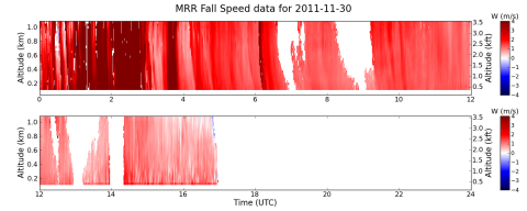
GHRC has published another GPM Cold-season Precipitation Experiment (GCPEx) dataset: GPM Ground Validation NASA Micro Rain Radar (MRR) GCPEx. This second generation MRR is a vertically pointing Doppler radar providing measurements of vertical velocity, drop size distribution, rainfall rate, attenuation, liquid water content, and reflectivity factor. The NASA MRR data was collected in Canada from late October 2011 through March 2013.

Sample browse image

Have you used our data? Register for updates