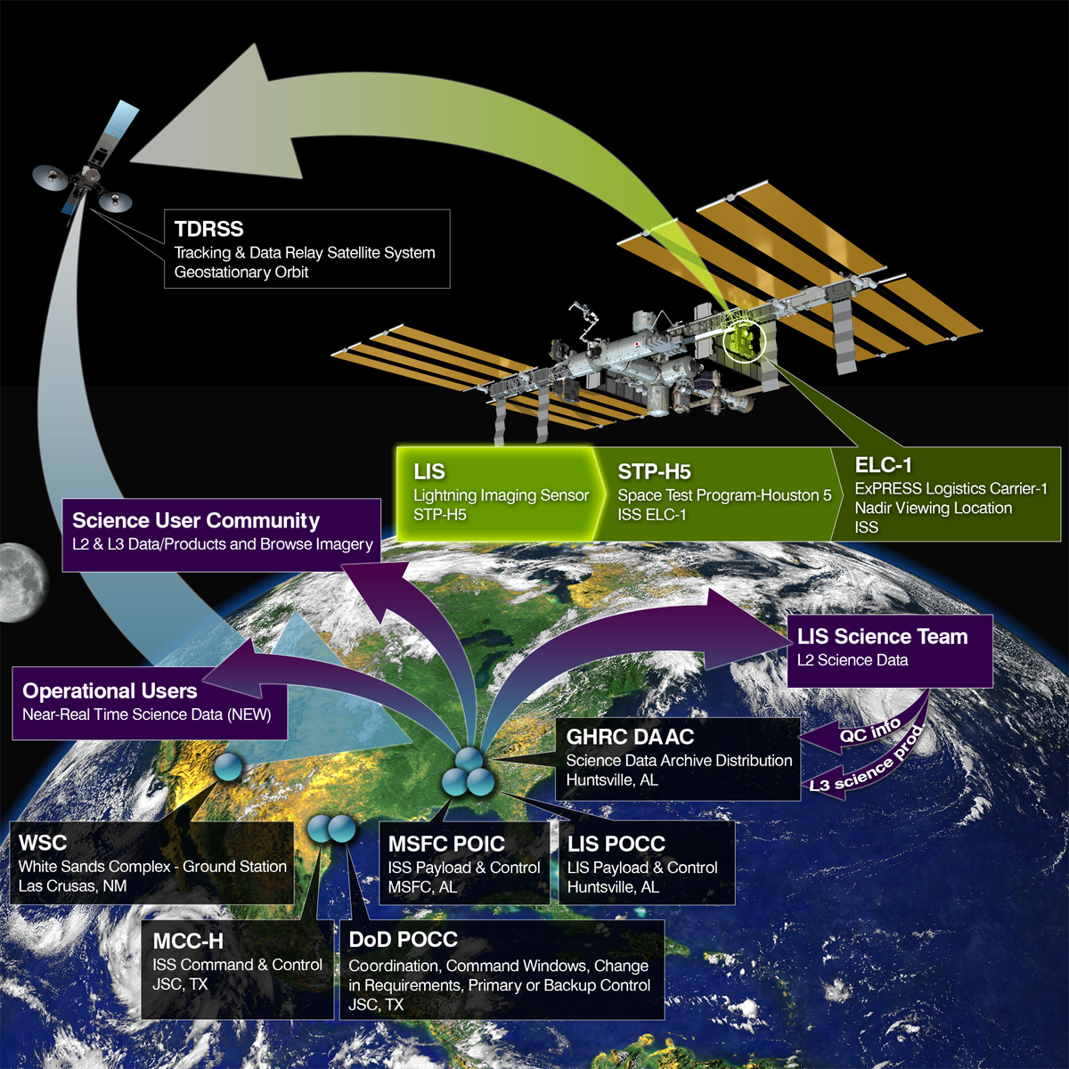
GHRC’s data processing and management team for the Lightning Imaging Sensor to be deployed to the International Space Station (ISS LIS) participated in the ISS LIS Mission Operations Internal Review on 12/20. This review focused on Payload Operations Center status, including computer systems, software, instrument health and status analysis, activation plan and nominal operations plan. Will Ellett, GHRC’s project manager for ISS LIS activities, presented GHRC status and plans to support the mission. Launch of the instrument is currently planned for early February, following SpaceX’s return to flight on January 8.
GHRC News
On December 7, the Science staff of the Global Hydrology Resource Center Distributed Active Archive Center (GHRC DAAC) held a quarterly telecon with the DAAC’s User Working Group (UWG). Primary topics included plans for the coming year for new micro articles related to GHRC datasets, approaches for curating virtual collections. UWG members provided guidance in both areas, and offered specific help in drafting and reviewing micro articles. The GHRC team also requested volunteers for subject matter experts to help with the Atmospheric Science User Forum, and shared plans for the GHRC presence at AGU.
GHRC DAAC staff attended the 2016 Fall Meeting of the American Geophysical Union (AGU) held in San Francisco, 12-16 December. GHRC-related posters and presentations include:
-
GHRC Talks/Posters
- [Talk] Flash Talk at NASA Booth about Field Campaign Explorer by Amanda Weigel. Scheduled for Thursday, 2:10 PM at the NASA Booth
- [Talk] ED13F-07: Earth Science Data Education through Cooking Up Recipes [Amanda Weigel] Monday 15:10, Moscone South Room 309
- [Poster] ED21B: Amazing Technologies and Capabilities that Contribute to STEM I, Poster Hall 189978: Making connections: Where STEM learning and Earth science data services meet [Kaylin Bugbee] Tuesday morning
- [Poster] IN33B: Near Real-Time Data for Earth Science and Space Weather Applications II, Poster Hall 185132: Land, Atmosphere Near Real-time Capability for EOS (LANCE) AMSR2 Data System [Deborah Smith] Wednesday afternoon
- [Poster] PA51A: Art and Design of Visualizations in the Geosciences: Inspiration, Interpretation, and Communication I, Poster Hall 190702: Art-inspired Presentation of Earth Science Research [Kaylin Bugbee] Friday morning
- [Poster] IN53C: Innovative Tools and Services to Enable Data Use across Broad User Communities I, Poster Hall 190508: Virtual Collections: An Earth Science Data Curation Service [Kaylin Bugbee] Friday afternoon
- [Talk] IN53E-07: Field Campaign Explorer: Simultaneous Data Exploration, Discovery, and Visualization [Amanda Weigel] Friday 15:10, Moscone West 2000
-
You may also be interested in other research by the GHRC team:
-
[Talk] IN11E-01 ECITE: A Testbed for Assessment of Technology Interoperability and Integration with Architecture Components [Sara Graves] Monday, 8:00 - 8:15, Moscone West
-
[Talk] IN14A-06 Riding the Hype Wave: Evaluating new AI Techniques for their Applicability in Earth Science [Rahul Ramachandran] Monday, 17:15 - 17:30, Moscone West - 2000
-
[Talk] IN22A-06 Public-Private Partnership: Joint recommendations to improve downloads of large Earth observation data [Rahul Ramachandran] Tuesday, 11:35 - 11:50, Moscone West – 2000
- [Poster] IN23C-1786: Evolving Frameworks for Different Communities of Scientists and End Users [Sara Graves] Tuesday, 13:40 - 18:00, Poster Hall
-
[Talk] IN52A-04 Deep Learning-Powered Insight from Dark Resources [Manil Maskey] Friday, 11:20 - 11:32, Moscone West - 2000
-
-
Chaired Sessions
-
IN33C: Collaborations, Partnerships, and Alliances that Are Building, Sustaining, and Stewarding Data and Research Infrastructures in Support of the New Era of the Big Data Transdisciplinary World II (Kaylin) Wednesday, 13:40 - 15:40, Moscone West - 2000
-
IN51C Spatial Data Infrastructure for Earth and Space Sciences: Analyzing, Visualizing, and Sharing Multidimensional Earth Science Data I Posters (Rahul, Manil) Friday, 08:00 - 12:20, Poster Hall
-
IN51D: Innovative Tools and Services to Enable Data Use across Broad User Communities I (Amanda) Friday 08:00 - 10:00 Room 2000 West
-
IN53C: Innovative Tools and Services to Enable Data Use across Broad User Communities II Posters (Amanda) Friday, 13:40 - 18:00, Poster Hall
- IN53E Spatial Data Infrastructure for Earth and Space Sciences: Analyzing, Visualizing, and Sharing Multidimensional Earth Science Data II (Rahul, Manil) Friday, 13:40 - 15:40, Moscone West - 2000
-
Here are some images from AGU 2016
The Global Hydrology Resource Center (GHRC) has published the GPM Ground Validation ACHIEVE W-Band Cloud Radar IPHEx (DOI: http://dx.doi.org/10.5067/GPMGV/IPHEX/WBAND/DATA101) dataset. The data were gathered during the the GPM Ground Validation Integrated Precipitation and Hydrology Experiment (IPHEx) Intensive Observing Period (IOP) in North Carolina from May 1, 2014 through June 15, 2014. The dataset includes data from the ProSensing 94 GHz W-Band cloud radar instrument, which is part of the NASA Goddard Space Flight Center (GSFC) Aerosol, Cloud, Humidity, Interactions Exploring and Validating Enterprise (ACHIEVE) ground-based mobile laboratory. The W-Band cloud radar is a scanning 94 GHz dual-polarization (horizontal transmission and co- and cross-polar receiving) Doppler radar used for observing liquid and ice clouds and light precipitation. The instrument also measures co- and cross-polar reflectivity, radial velocity, Doppler spectrum width, and signal-to-noise ratio. Linear depolarization ratio was derived from the measured parameters. During the IPHEx campaign the W-Band radar was used exclusively in vertical-pointing mode. Data files are available in netCDF3 data format.
The AMSR Science Investigator-led Processing System (SIPS) at the GHRC DAAC has completed integration and testing of the AMSR Unified (AMSR-U) version 1-beta Level-2 Land, including end-to-end testing with the NSIDC DAAC. The Level-2 Land algorithm is the first generating AMSR-U standard products and is now running routinely in production at the SIPS. The AMSR-U Level 2B surface soil moisture products are generated from the Japanese Aerospace Exploration Agency’s (JAXA) AMSR2 L1R brightness temperatures using two distinct algorithms: the Normalized Polarization Difference (NPD) algorithm and the Single Channel Algorithm (SCA).